Keywords: Climate change, Invertebrates, Nearshore habitat, Estuarine habitat, Resilience, Sea level rise, Floodplains, Salish Sea Currents magazine

A pilot project to create a 'living dike' in Canada's Boundary Bay is designed to help a saltwater marsh survive rising waters due to climate change.


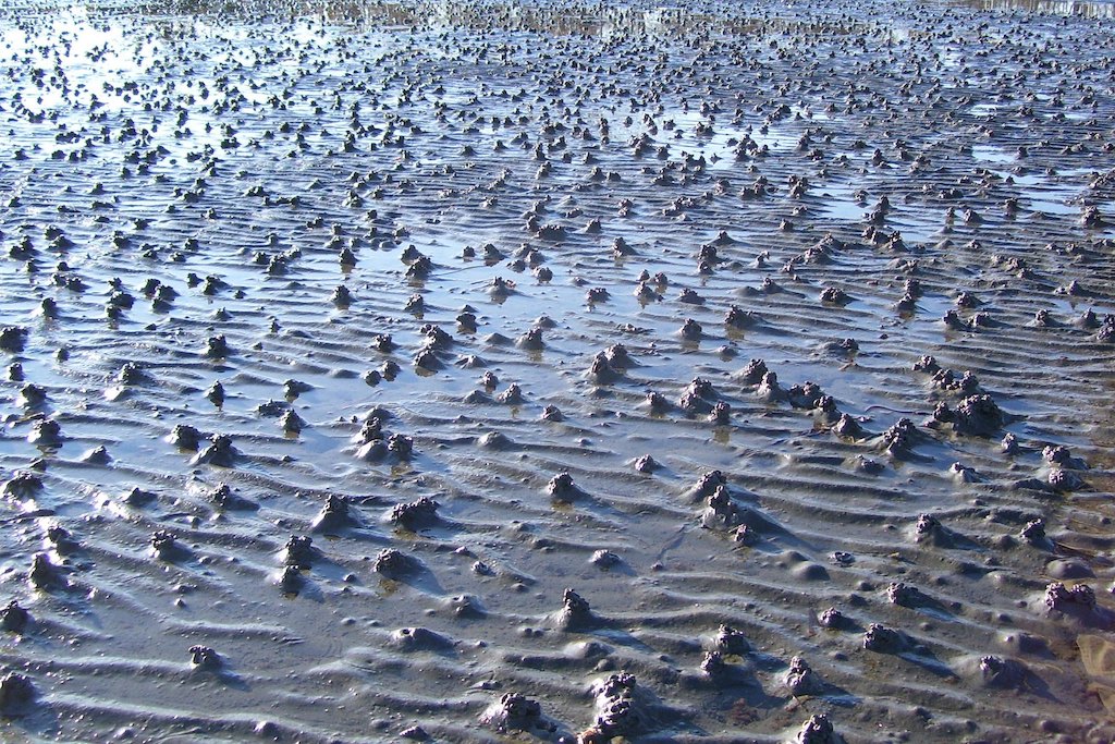
Every year, 45 cubic meters of sediment arrive for every meter along a stretch of shoreline in Boundary Bay, near the U.S.-Canada border on the eastern shore of the Salish Sea. The volume is equivalent to the capacity of two and a half tandem trucks, a type of large dump truck commonly used in construction projects. But the sediment at Boundary Bay is not delivered by tandem trucks. It’s transported by worms, shrimps, and ducks, in tandem with winds and tides.

The activities of living organisms, primarily the relentless feeding and excreting of obscure intertidal invertebrates, represent a “biogenic sediment machine” that may be a key contributor to salt marsh formation and resilience, says John Readshaw, a coastal engineer with SNC Lavalin, Inc., who presented the findings at the 2022 Salish Sea Ecosystem Conference on April 27.

The unexpected discovery grew out of regular ‘walkabouts’ that Readshaw and marine wetlands biologist Gary Williams have been making since last May around the mudflats and salt marsh near 96th Street in Delta, British Columbia. The location is the site of a planned pilot project for a ‘living dike,’ a nature-based approach to shoreline protection that is designed to grow, shift, and self-heal as sea level rises. Other living dikes are being built along the U.S. Gulf Coast and in the Netherlands, where engineers hope the structures will provide better protection from storm surge and floods than conventional dikes and seawalls. The sediments can also protect marshes from being inundated as they get "squeezed" against existing hard armor.

Two illustrations showing the concept of a living dike

A living dike is designed to assist with the upward migration of the foreshore and the growth of existing upper intertidal marshes along an existing dike. (Above) Existing sediment and marsh (sand colored and dark green plants) with a bench of new sediment (light green) and some planting seaward of the existing marsh. (Below) As sea level rises, new sediment (which is periodically overlain with fresh sediment and plantings, if necessary) fills out the seaward edge and becomes an established marsh. Illustrations: Courtesy John Readshaw/SNC-Lavalin

Readshaw and Williams have been visiting the Delta site every two weeks to every month, sometimes with other experts in tow, in an effort to better understand the natural dynamics at play. “Understanding coastal processes is fundamental in coming up with solutions,” Readshaw says.

The researchers soon noticed that at low tide, the mud flats were covered with little mounds of sediment excavated by burrowing organisms “as far as the eye can see,” as Readshaw describes it. There were toothpaste-like castings of lugworms, for example, and gently sloping mounds built by ghost shrimp. (Later, the researchers realized that vertebrates are involved in moving sediments, too – such as scoters, sea ducks that forage in the muck for clams and other bivalves.)

As the tide came in, the loose sediment mounds mobilized, and the researchers wondered just how much. Readshaw combed through the scientific literature on mud-flat organisms and made a spreadsheet. Each mound represents anywhere from a thimbleful to a cupful of sediment, depending on the species that excavated it. But given the density of burrowing organisms on the mud flat, it all adds up fast: 0.7 cubic meters of sediment per meter of beach per tide cycle.

Salt marsh and tidal flats with mountains in the distant background

Salt marsh and tidal flats of Boundary Bay. Photo: Joe Mabel, via Wikimedia Commons CC BY-SA 3.0

Taking into account additional factors, such as seasonal changes and the varying width of the tidal flat along the beach, Readshaw’s spreadsheet suggests that the organisms provide 45 cubic meters of sediment per meter of shoreline per year.

Not all of the sediment necessarily stays on the beach. The researchers estimate that about 50% of the volume may be carried out with the ebb tide and 10% is taken into neighboring burrows. The remaining 40% is transported ashore by the flood tide, sea breeze, and fall and winter storms, then held in place by millimeters-thick mats of algae that form each spring and, as the salt marsh continues to develop, the roots of plants.

To what degree this naturally deposited sediment could hedge against sea level rise is still an open question. Current projections show that the water is rising too fast for the invertebrate engineers to keep pace. Yet their contributions are substantial: more than enough to account for the increase in the elevation of the salt marsh since the existing, conventionally constructed Boundary Bay dike was built in 1892, according to Readshaw’s calculations. To help nature along, the living dike project will provide sand from the Fraser River to sub-tidal and intertidal areas along a 14 kilometer stretch of the Boundary Bay shoreline. The sand will be added gradually, over a period of 30 years, allowing natural processes to take hold.

More studies will be necessary to quantify the dynamics of intertidal burrowers and the capacity of the biogenic sediment machine with more precision. But the researchers say the prospects are intriguing. “Mud flats are fascinating, because it doesn’t look like much, but the more you know, it triggers about 1,000 more questions and you realize how complex it is,” says Williams.  


About the author: Sarah DeWeerdt is a Seattle-based freelance science writer specializing in biology, medicine, and the environment. Her work has appeared in publications including Nature, Conservation, and Nautilus.