

Like many others in Whatcom County and elsewhere, when Althea Wilson first heard the reports and saw the dramatic images of Nooksack River flooding last year, she worried for the people who had lost homes and livelihoods, and whose physical safety was threatened.
But she also had a more unusual reaction: “Please don't blame the river,” she thought.
Wilson, a Lummi tribal member and Native Environmental Science curriculum coordinator at Northwest Indian College in Bellingham, completed an oral history project about life on the Nooksack River in 2018. Her interviews with tribal elders revealed a waterway that was rich in resources and contributed to a thriving Indigenous community that some outsiders dismissed as “river rats.”
The river, too, has been misunderstood, Wilson thinks. “It makes a lot of contributions to the Salish Sea that people really tend to overlook,” she says. “The only time that it gets any attention is when it so-called rears its ugly head to flood every so often.”
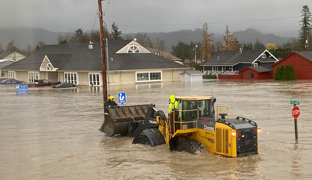
That’s what happened in November 2021, when intense rainfall from a series of atmospheric rivers loaded with water vapor from the tropics caused the river to overflow its banks, destroying homes, killing livestock, blocking roads, and damaging infrastructure in northern Whatcom County communities such as Everson, Nooksack, and Sumas. Waters from the river also contributed to historic flooding in Sumas Prairie and Abbotsford, British Columbia.
Periodic flooding has long been a pattern along the Nooksack River, as Wilson’s interviews with tribal elders showed. “They talked about the flooding as if it was just another fact of life,” she says.
Particularly in the late fall, heavy snowfall at low elevations followed by warmer temperatures and rainfall that melts the snow can send a massive surge of water raging down the Nooksack, which runs for 75 miles from Mount Baker to Bellingham Bay. “Those types of hydrologic events are natural in our watershed, they're just happening more frequently and have greater magnitude due to climate change,” says Oliver Grah, water resources manager for the Nooksack Indian Tribe.
Climate change means more intense rains, and more precipitation that falls as rain rather than snow – which runs off more quickly. Land use change exacerbates the problem: clearcuts in the upper Nooksack watershed compact the soil and remove mature forests that could effectively soak up moisture. Clearing and development of riparian forests in the lowlands has further reduced the buffer against flooding.
Shifting boundaries
The Nooksack is a short river with a complex story. It was once a tributary of the Fraser River, but at some point – perhaps a few thousand years ago, perhaps a few hundred – it abruptly shifted course.
“The lower extent of the Nooksack River is really part of the Fraser River delta,” Grah says. Over geologic time, the Fraser “has reworked and worked” a wide swath of territory between the North Shore Mountains north of Vancouver, BC and the Chuckanut Mountains south of Bellingham. Today, a ramrod-straight international border runs through this shifting landscape.
Although the Nooksack’s present-day channel never enters Canada, a portion of the river’s 790-square-mile watershed lies north of the border. Three major tributaries of the Nooksack, Bertrand Creek, Pepin Brook, and Fishtrap Creek, originate in Canada. And when the Nooksack overtops its banks – especially around the town of Everson, which is thought to be the site of the avulsion, or shift in the river’s course – its waters seek their former pathway to the sea.


