Water Resource Inventory Areas in Puget Sound
The Washington State Department of Ecology and other state natural resources agencies have divided the Washington into 62 "Water Resource Inventory Areas" or "WRIAs" to delineate the state's major watersheds.

Water Resource Inventory Areas (WRIA) were formalized under Washington Administrative Code (WAC) 173-500-040 and authorized under the Water Resources Act of 1971, Revised Code of Washington (RCW) 90.54. Ecology was given responsibility for the development and management of these administrative and planning boundaries. These boundaries represent the administrative under pinning of this agency’s business activities. The original WRIA boundary agreements and judgments were reached jointly by Washington's natural resource agencies Ecology, Department of Natural Resources, and Washington Department of Fish and Wildlife in 1970 and were updated in 1998 and 2000.
The following article lists and describes the WRIAs that fall within the Puget Sound Basin.
 WRIA 1: Nooksack basin

Most of the Nooksack basin is located within Whatcom County, but parts of the South Fork Nooksack basin extends southwards into Skagit County. The northern boundary of Nooksack basin is the U.S./Canadian border and the southern border includes Colony Creek. The eastern boundary consists of these streams’ glacial headwater sources in the Cascade Mountain Range, while the area extends west to the photosynthetic zone of the near shore environment. It also includes streams that are located within Whatcom County, but are tributaries to the Fraser River in Canada (e.g. Sumas, Chilliwack Rivers). The Washington State Department of Fish and Wildlife Stream Catalog list 654 streams and 1325 linear miles of streams in Nooksack basin (Phinney and Williams 1975). Currently, 82% of the Whatcom County lands are forest and rural lands, 9% consist of agricultural use, 3% are residential lands, 2% are urbanized, and the remainder consists of industrial, mining, and commercial development (Whatcom County Planning and Development Services Dept. 1997).
- Additional information for WRIA 1
- Source: SALMON AND STEELHEAD HABITATLIMITING FACTORS IN WRIA 1, THE NOOKSACK BASIN July, 2002 Carol J. Smith, Ph.D. Washington State Conservation Commission
- USGS Water Resources Links for: HUC 17110004 - Nooksack
- USGS Water Resources Links for: HUC 17110002 - Strait of Georgia
- USGS Water Resources Links for: HUC 17110001 - Fraser
 WRIA 2: San Juan Islands

The San Juan Islands are a group of 175 islands located to the east of Victoria, British Columbia, west of Anacortes and north of Puget Sound. The Islands have approximately 117,846 acres of land of which 10,036 acres are within 200 feet of the shoreline. Lying in the rain shadow created by the mountains on the Olympic peninsula and Vancouver Island, they have the smallest landmass of any county in Washington and the longest shoreline of any county in the United States. Collectively the Islands contain over 90 freshwater streams with a total length of approximately 100 miles. The San Juan Islands were once part of a mountain range connecting Washington to Vancouver Island. Eighty-three islands are protected as part of the San Juan Wildlife Refuge. The four major islands are Lopez, Orcas, San Juan, and Shaw and the majority of the permanent and transient population resides on these islands. About 40 of the other islands have either permanent or temporary residents.
- Additional information for WRIA 2
- Source: Salmon and Steelhead Habitat Limiting Factors Report for the SAN JUAN ISLANDS (Water Resource Inventory Area 2) Prepared by: John Kerwin Washington Conservation Commission Olympia, Washington February 2002
- USGS Water Resources Links for: HUC 17110003 - San Juan Islands

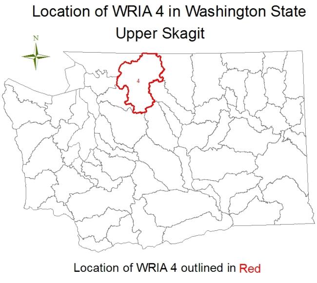
 WRIA 3 & 4: Upper/Lower Skagit watershed


The two major freshwater drainages within the WRIA 3& 4: Upper/Lower Skagit watersheds are the Samish and Skagit Basins. The Skagit Basin is further divided into four sub-basins, the lower Skagit (downstream from the Sauk River), the upper Skagit (between the Sauk River and the upper end of the anadromous zone), the Sauk, and the Baker River sub-basins. In addition, there are several smaller independent sloughs and watersheds within the two WRIAs. Much of the Skagit Basin is within Skagit County. However, the northern boundary of the WRIAs extends into Whatcom County, and the northeastern region ends at the U.S./Canadian border, although the Skagit drainage originates in British Columbia. The southern border continues into Snohomish County with Douglas Slough to the west, and the headwaters to the Sauk River further eastward. The western boundary includes all the waters and shorelines within Skagit County, such as Cypress, Guemes, Sinclair, Burrows, Allen, and Fidalgo Islands. The Skagit Basin is the largest drainage in Puget Sound, supplying over 30 percent of the freshwater to Puget Sound, an estimated 10 billion gallons of water a day (North Cascades Institute 2002). The Washington State Department of Fish and Wildlife Stream Catalog lists 2,989 streams and 4,540 linear miles of streams in these two WRIAs (Phinney and Williams 1975).
- Additional information for WRIA 3
- Additional information for WRIA 4
- Source: SALMON AND STEELHEAD HABITAT LIMITING FACTORS WATER RESOURCE INVENTORY AREAS 3 AND 4, THE SKAGIT AND SAMISH BASINS By Carol J. Smith, Ph.D. Washington State Conservation Commission Lacey, Washington With a Contributing Chapter by Devin Smith (Skagit System Cooperative) and Tyson Waldo (Northwest Indian Fisheries Commission)
- USGS Water Resources Links for: HUC 17110005 - Upper Skagit
- USGS Water Resources Links for: HUC 17110007 - Lower Skagit
 WRIA 5: Stillaguamish River basin

The Stillaguamish River is the fifth largest tributary to Puget Sound which ranks behind the Skagit, Snohomish, Puyallup, and Nooksack river systems (Miller and Somers 1989). The river drains a 1,774-km2 watershed on the west slope of the North Cascades (Embry 1987). The mainstem of the river enters Puget Sound near the town of Stanwood, 25 km north of Everett (Collins 1997). The Stillaguamish watershed can be divided into three large sub-basins: the North Fork, the South Fork, and the lower mainstem. The mainstem divides into two distributary channels near its mouth: Hat Slough (originally called Hatt’s Slough), and the old Stillaguamish channel. The latter drains into Skagit Bay via West Pass and into Port Susan via South Pass. The North and South Forks join together at Arlington, 28 river kilometers from the mouth (Collins 1997). The North Fork drains 736 km2 (42 %) of the Stillaguamish Watershed. The South Fork is slightly smaller, draining 660 km2 (37 %) of the watershed. The three largest tributaries include: Pilchuck Creek, draining to the mainstem and accounting for 11 % of the watershed area; Deer Creek, draining to the North Fork, and accounting for 10 % of the watershed area; and Canyon Creek, draining to the South Fork, and accounting for 8 % of the total watershed area. The Stillaguamish watershed has been divided into 27 sub-basins for management use by tribal, state, and local natural resource agencies (Pollock and Pess 1998). The sub-basins range in size from 10 km2 to 176 km2.
- Additional information for WRIA 5
- Source: SALMON HABITAT LIMITING FACTORS FINAL REPORT WATER RESOURCE INVENTORY AREA 5 STILLAGUAMISH WATERSHED WASHINGTON STATE CONSERVATION COMMISSION July 1999
- USGS Water Resources Links for: HUC 17110008 - Stillaguamish
 WRIA 6: Island County

Island County is located in north Puget Sound and is bounded on the north by Deception Pass, on the east by Skagit Bay, Port Susan and Possession Sound, and on the west by the Strait of Juan de Fuca and Admiralty Inlet. The boundaries of Island County include five islands: Whidbey, Camano, Ben Ure, Strawberry and Smith. Whidbey and Camano Islands together cover about 538 km2. Whidbey Island is the largest island in Puget Sound and in the contiguous United States. It is bounded by Skagit Bay and Deception Pass (north), Admiralty Inlet (west), Possession Sound (south), and Saratoga Passage (east). Whidbey is about 104 km long, from 1.6 km to 16 km wide, encompasses 437 km2, and includes 249 km of shoreline. Camano Island is located between Whidbey Island and the mainland of Washington State. It is the second largest island in Puget Sound. Camano Island is bounded by Skagit Bay (north), Saratoga Passage (west), Possession Sound (south) and Port Susan (east). It is approximately 24 km long, 1.6 km to 11 km wide, covers 104.3 km2, and includes 85.0 km of shoreline.
- Additional information for WRIA 6
- Source: SALMON HABITAT LIMITING FACTORS WATER RESOURCE INVENTORY AREA 6 ISLAND COUNTY WASHINGTON STATE CONSERVATION COMMISSION April 2000
- USGS Water Resources Links for: HUC 17110019 - Puget Sound
 WRIA 7: Snohomish watersheds

The Snohomish River watershed, draining 1980 mi2 west of the Cascade Crest, is the second largest river basin draining to Puget Sound (Pentec and NW GIS 1999). Elevations in the watershed range from sea level to 8,000 feet (Gersib et al. 1999). The watershed includes three major rivers, the Skykomish, the Snoqualmie, and the Snohomish, which flow west through broad, glaciated lowland valleys and enter Puget Sound near Everett. The Snohomish River watershed is also a major source of municipal water for Everett, southwest Snohomish County, Seattle, Bellevue, and other cities and areas in King County (Pentec and NW GIS 1999). The Skykomish River drains 842 mi2 and is the largest drainage in the Snohomish River Basin (Gersib et al. 1999). The Snoqualmie River drains the southern 694 mi2 portion of the Snohomish River Basin, and flows over a relatively unconfined alluvial floodplain (Gersib et al. 1999). The Snohomish River drains 332 mi2 and flows through the lower 21 miles of the river basin (Gersib et al. 1999). Land uses in the Snohomish River watershed are strongly associated with physical geographic features (Pentec and NW GIS 1999). Private and federal forest lands and federal wilderness areas in the Cascades constitute 74% of the watershed area. Agricultural lands dominate the flat floodplains of the Snoqualmie and Snohomish rivers and account for about 5% of the watershed area. Rural residential development is scattered throughout the floodplains and surrounding plateaus. Urban lands are concentrated in Everett and Marysville (at the mouth of the Snohomish River), and in smaller cities located along the rivers up to the Cascade Mountains.
- Additional information for WRIA 7
- Source: SALMONID HABITAT LIMITING FACTORS ANALYSIS SNOHOMISH RIVER WATERSHED WATER RESOURCE INVENTORY AREA 7 FINAL REPORT WASHINGTON STATE CONSERVATION COMMISSION Donald Haring December 2002
- USGS Water Resources Links for: HUC 17110011 - Snohomish
 WRIA 8: Cedar and Sammamish basin

The Cedar and Sammamish Basin is located predominantly within the borders of King County, but 15 percent of it extends northward into Snohomish County. To the west it is bounded by Puget Sound, while to the east the headwaters of the Cedar River reach the crest of the Cascade Range near Stampede Pass. The northern and southern boundaries follow hilltops, ridges and plateaus that define the drainage divides between the Snohomish/Snoqualmie and Green/Duwamish watersheds, respectively. The lakes and two main rivers of the basin are fed by numerous tributaries that drain a network of streams, ponds, wetlands and 35 aquifers. Out of the 692 square miles in the Cedar and Sammamish Basin, 607 are in the Cedar - Sammamish watershed, which contains two major river systems, the Cedar and the Sammamish, and three large lakes, Union, Washington and Sammamish. The remainder of the basin consists of numerous small watersheds that drain directly to Puget Sound between Elliott Bay and Mukilteo. Lake Washington is the second largest natural lake in the state, with about 80 miles of shoreline (including about 30 miles along the shore of Mercer Island) and a surface area of about 35.6 square miles.
- Additional information for WRIA 8
- Source: Salmon and Steelhead Habitat Limiting Factors Report for the CEDAR – SAMMAMISH BASIN (Water Resource Inventory Area 8) Prepared by: John Kerwin Washington Conservation Commission Olympia, Washington September 2001
- USGS Water Resources Links for: HUC 17110012 - Lake Washington
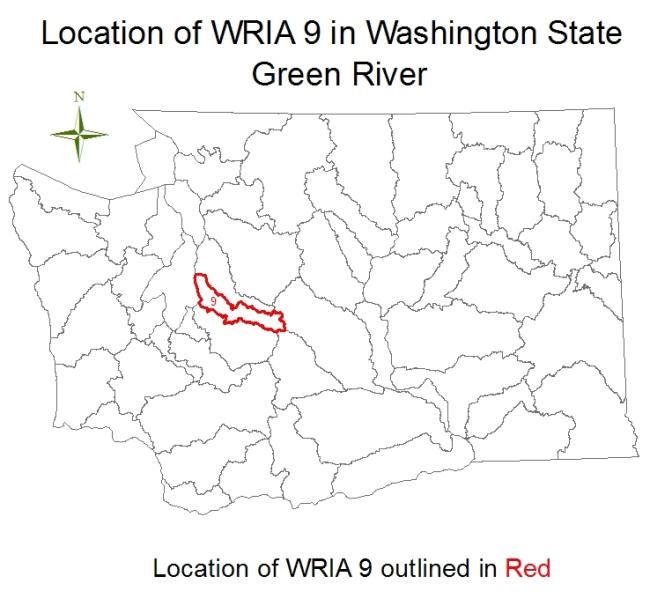
 WRIA 9: Green River watersheds

The Green/Duwamish River is the largest freshwater component of Green River Watershed. The Green/Duwamish River watershed begins in the Cascade Mountains about 30 miles northeast of Mount Rainier and flows for over 93 miles to Puget Sound at Elliott Bay in Seattle. It is bounded on the north by the Lake Washington watershed and to the south by the Puyallup watershed. Historically, the White, Green, and Cedar (via the Black) Rivers flowed into the Duwamish River, and the system drained an area of over 1,600 square miles. Because of the diversion of the White River in 1911 and the Cedar River in 1916, the Green/Duwamish drainage area has been reduced to 556 square miles. Land uses differ considerably across the watershed. In the Upper Green River Sub-watershed, land is devoted almost entirely to forest production. The Middle Green River Sub-watershed is characterized by a mix of residential, commercial forestry, and agricultural land uses. Residential, industrial, and commercial uses prevail in the Lower Green River Sub-watershed. The Green/Duwamish River Sub-watershed is split between residential and industrial uses. Independent tributaries to Puget Sound, including Vashon-Maury Islands, are primarily residential with small areas of commercial development and mining.
- Additional information for WRIA 9
- Source: Green/Duwamish and Central Puget Sound Watersheds (Water Resource Inventory Area 9 and Vashon Island) Executive Summary December 2000 King County and Washington State Conservation Commission
- USGS Water Resources Links for: HUC 17110013 - Duwamish
 WRIA 10: White-Puyallup River basin

The Puyallup basin drains an area of approximately 1,065 square miles, has over 728 miles of rivers and streams which flow over 1,287 linear miles. Included in the watershed are more than a dozen cities and towns, including Washington State’s third largest city, Tacoma. The Puyallup River basin has been substantially altered from its historic condition. In particular, the lower river bears little resemblance to its historic past. Extensive urban growth, heavy industry, a large modern marine port, an extended revetment and levee system and agriculture have combined to significantly alter the natural landscape. Annual average rainfall in the basin ranges from 40 inches at the city of Puyallup to 70 inches at Electron Dam. Mountain snowpack has been recorded at up to 150 inches. Eighty percent of this precipitation occurs in the fall and winter months. Sixty percent of the Puyallup basin lies at an elevation between 1,000 and 4,000 feet, an area where neither rain nor snow predominates. This topographical feature often leads to moisture conditions that are capable of generating tremendous amounts of runoff. These flood events normally occur in the winter months and are followed by less severe spring runoffs generated by snowmelt.
- Additional information for WRIA 10
- Source: Salmon Habitat Limiting Factors Report for the PUYALLUP RIVER BASIN (Water Resource Inventory Area 10) Prepared by: John Kerwin Washington Conservation Commission Olympia, Washington July 1999
- USGS Water Resources Links for: HUC 17110014 - Puyallup
 WRIA 11: Nisqually watershed

The Nisqually watershed includes the Nisqually River which originates from the Nisqually Glacier on the southwest slopes of Mount Rainier and three independent tributaries (McAllister Creek an unnamed creek and Red Salmon Creek) draining directly into Puget Sound. The Nisqually River flows northwesterly for approximately 72 miles before joining Puget Sound. The entire basin encompasses approximately 720 square miles and the principle drainage basin; the Nisqually River includes over 331 identified streams and 715 linear miles of river and stream channels (Williams 1975). Annual average rainfall in the basin ranges from approximately 40 inches at the Olympia Airport to more than 140 inches in Mount Rainier National Park. Generally, sixty percent of this precipitation occurs in the fall and winter months (September thru March). Approximately sixty percent of the Nisqually basin lies at an elevation between 1,000 and 4,000 feet, an area where neither rain nor snow predominates. This topographical feature often leads to precipitation conditions that are capable of generating tremendous amounts of runoff. These flood events normally occur in the winter months and are followed by less severe spring runoffs generated by snowmelt.
- Additional information for WRIA 11
- Source: SALMON AND STEELHEAD HABITAT LIMITING FACTORS WATER RESOURCE INVENTORY AREA 11 WASHINGTON STATE CONSERVATION COMMISSION FINAL REPORT John Kerwin 01/21/99
- USGS Water Resources Links for: HUC 17110015 - Nisqually
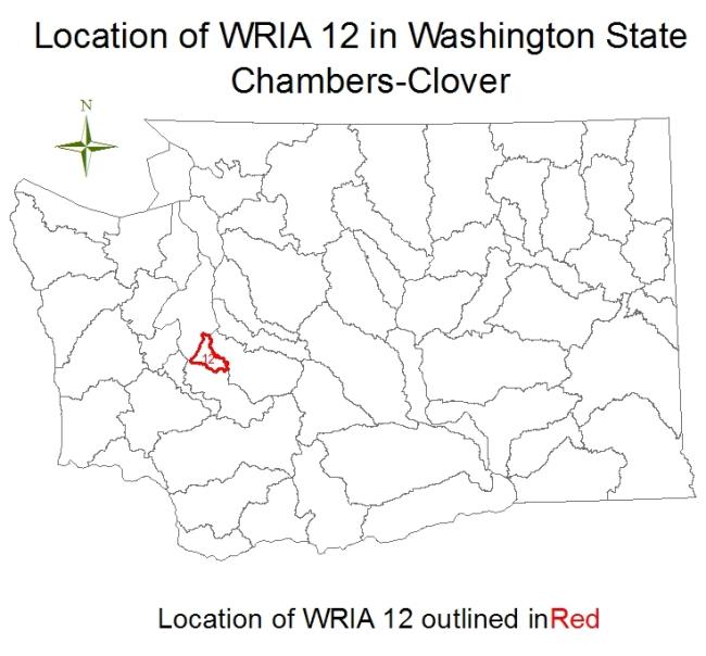
 WRIA 12: Chambers-Clover watershed

The Chambers-Clover watershed is located in central Pierce County and is roughly triangular in shape, bounded by Puget Sound on the west, and extends east to near the community of Graham. Point Defiance and the southwest shore of Commencement Bay serve as the northern boundary. The City of DuPont near the Nisqually River Basin is located near the southern boundary. The Chambers-Clover watershed covers approximately 180 square miles (Clothier, et al 2003). This watershed comprises the Chambers-Clover Creek Basin and the neighboring small drainages of Sequalitchew (including American Lake and Murray Creek) and Puget Creeks in Pierce County, Washington. It also encompasses several independent stream drainages, including unnamed creeks draining from the North Tacoma area directly into Puget Sound, and Crystal Springs Creek. Important lakes within the Chambers-Clover watershed are Lake Louise, Owens Marsh, and Steilacoom, Gravelly, American, Spanaway, Waughop, Charlton, and Wapato Lakes (Clothier, et al 2003). The watershed includes approximately the western half of the City of Tacoma, all of the Cities of Lakewood and University Place, and the Towns of Steilacoom, Dupont, Fircrest, and Ruston. It also includes the unincorporated communities of Parkland, Spanaway, Elk Plain, Frederickson, and Midland. McChord Air Force Base and part of Fort Lewis occupy a large portion of the central and southern part of the basin (Clothier, et al 2003).
- Additional information for WRIA 12
- Source: SALMONID HABITAT LIMITING FACTORS ANALYSIS CHAMBERS-CLOVER CREEK WATERSHED (Including Sequalitchew Creek and Independent Tributaries) WATER RESOURCE INVENTORY AREA 12 Judy Runge, Marc Marcantonio, and Monty Mahan. Pierce Conservation District. June 2003
- USGS Water Resources Links for: HUC 17110019 - Puget Sound
 WRIA 13: Deschutes River watershed

The Deschutes River watershed is located at the southern end of Puget Sound, almost entirely within the bounds of Thurston County, with a small portion (the headwaters of the Deschutes River) in Lewis County. The drainages of the watershed empty into three saltwater inlets that, in turn, define the major watersheds: Henderson Inlet to the East, centrally located Budd Inlet, and Eld Inlet to the West. The Deschutes River is the major hydrologic basin in the Deschutes River watershed, with a number of other smaller independent tributaries to salt water. The Henderson Inlet watershed lies in the northeast section of the Deschutes River watershed and has a total drainage area of about 29,275 acres (Thurston County 1989). Budd Inlet is located between Henderson Inlet to the east and Eld Inlet to the west. The inlet is about 7 miles long and has an average width of 1.15 miles. The average depth is 27 feet with a maximum depth of 110 feet occurring near the mouth of the inlet. The inlet is classified as a shallow, poorly mixing estuary. The entire Eld Inlet watershed encompasses approximately 23,220 acres. The primary streams in the watershed are McLane Creek, its tributaries, and Green Cove Creek. The McLane Creek drainage system incorporates a total of 7,360 acres.
- Additional information for WRIA 13
- Source: WASHINGTON STATE CONSERVATION COMMISSION SALMON HABITAT LIMITING FACTORS FINAL REPORT WATER RESOURCE INVENTORY AREA 13 Donald Haring and John Konovsky July, 1999
- USGS Water Resources Links for: HUC 17110016 - Deschutes
 WRIA 14 south: Kennedy - Goldsborough basin

The Kennedy-Goldsborough basin covers about 381 square miles of southwest Puget Sound. The area is drained by many small independent streams; no major river system is present. Streams generally flow north and east from rolling hills located between the inlets of southern Puget Sound and the Olympic Mountains to the north. One hundred thirty-nine independent streams, traversing approximately 240 linear miles have been identified. Streams are generally lowland types with headwaters originating from springs, surface water drainage, wetlands, beaver ponds, or small lakes. Upper watersheds are typically moderately to heavily forested with large acreages of second and third growth coniferous trees. Most streams originate in steep ravines, gradually transition to broad valley bottoms dominated by alder and brush, then flow through tide flats. Rural and urban developments are usually associated with the lower portions of streams near salt water bays (Washington Department of Fisheries 1975). High density residential development occupies only 1.1% of the basin, primarily in the Shelton area.
- Additional information for WRIA 14
- Source: SALMONID HABITAT LIMITING FACTORS WATER RESOURCE INVENTORY AREA 14, KENNEDY GOLDSBOROUGH BASIN FINAL REPORT NOVEMBER 2002 Michael Kuttel, Jr. Washington State Conservation Commission
- USGS Water Resources Links for: HUC 17110019 - Puget Sound
 WRIA 14 north and WRIA 15 west: Kitsap basin and Kennedy-Goldborough basin

North WRIA 14 covers about 22.5 square miles and includes all WRIA 14 streams that drain to the south shore of Hood Canal. The majority of streams in this area are 0.5 to 2 miles in length.
West WRIA 15 extends from Foulweather Bluff at the mouth of the Hood Canal southward along the shoreline to the terminus of the east arm of the Hood Canal. The eastern boundary extends to the headwaters of all streams draining to the east shore of Hood Canal. The basin covers about 290 square miles of the Kitsap Peninsula. The west Kitsap Basin has been divided into four sub-basins. The Port Gamble Sub-basin is the northern most sub-basin and extends from Foulweather Bluff south to the community of Olympic View. The Big Beef-Anderson Sub-basin begins near Olympic View and extends south to the community of Holly. The Tahuya-Dewatto Sub-basin extends from Holly south and east to the eastern edge of the Tahuya River Watershed. The Union-Mission Sub-basin encompasses the watersheds east of the Tahuya River Watershed and south of the Union River within WRIA 15.
- Additional information for WRIA 14
- Additional information for WRIA 15
- Source: SALMONID HABITAT LIMITING FACTORS WATER RESOURCE INVENTORY AREAS 15 (WEST), KITSAP BASIN AND 14 (NORTH), KENNEDY-GOLDSBOROUGH BASIN FINAL REPORT JUNE 2004 Michael Kuttel, Jr. Washington State Conservation Commission
- USGS Water Resources Links for: HUC 17110019 - Puget Sound
- USGS Water Resources Links for: HUC 17110018 - Hood Canal
WRIA 15 east: Key Peninsula, Gig Harbor, Islands, Colvos Passage
East WRIA 15 includes the streams and marine waters on the Puget Sound side of Key Peninsula, Gig Harbor Peninsula, South Puget Sound Islands, and Kitsap Peninsula. There are numerous low-elevation, low-gradient streams throughout East WRIA 15. There are 125 separate streams entering saltwater in East WRIA 15. Individual drainage lengths range from single channels less than 1 mile in length to larger drainages with numerous tributaries. The larger drainages in East WRIA 15 include Coulter Creek, Rocky Creek, Minter Creek, Burley Creek, Crescent Creek, Curley Creek, Blackjack Creek, Gorst Creek, Chico Creek, Clear Creek, Dogfish Creek, and Grovers Creek. WRIA 15 is quite unique in comparison to other western Washington watersheds as the entirety of the WRIA is low-elevation and low-gradient. The drainages are relatively small in comparison to larger river systems, and flows are dependent on precipitation and groundwater contribution, as the drainages do not receive snowmelt runoff from either the Olympic or Cascade Mountains.
- Additional information for WRIA 15
- Source: SALMONID HABITAT LIMITING FACTORS WATER RESOURCE INVENTORY AREA 15 (East) FINAL REPORT WASHINGTON STATE CONSERVATION COMMISSION Donald Haring November 2000
- USGS Water Resources Links for: HUC 17110018 - Hood Canal
- USGS Water Resources Links for: HUC 17110019 - Puget Sound
 WRIA 16: Skokomish and Dosewallips watersheds

The Skakomish and Dosewallips watersheds (WRIA 16) is located within the eastern slope of the Olympic Mountains in Washington State. The WRIA extends from the Turner Creek watershed in southeast Jefferson County southward to, and including, the Skokomish watershed in northwest Mason County. The four principal watersheds, the Dosewallips, the Duckabush, the Hamma Hamma and the Skokomish, originate in the rugged terrain of the Olympic Mountains and terminate along the western shore of Hood Canal. Numerous smaller independent streams are interspersed between the larger river systems. The region has a temperate, marine climate with wet winters and dry summers with precipitation ranging from approximately 60 inches per year along Hood Canal to approximately 120 inches per year near the headwaters of the major rivers (USFS 1999). WRIA 16 lies within the eastern slope of the Olympic Mountains along the western shore of Hood Canal. The four principal watersheds, the Dosewallips, the Duckabush, the Hamma Hamma and the Skokomish, originate in the rugged terrain of the Olympic National Park or Olympic National Forest. Numerous smaller independent streams are interspersed between the larger river systems and drain the lower foothills. There are 557 identified streams contributing over 825 linear miles of rivers, tributaries and independent streams within WRIA 16 (Williams et al. 1975). There are no incorporated cities in WRIA 16. The two largest population centers, Brinnon to the north and Hoodsport to the south, are situated on SR101 and maintain a rural character. Smaller communities include Eldon, Lilliwaup and Potlatch. The majority of the residential development in WRIA 16 is along the shoreline of western Hood Canal.
- Additional information for WRIA 16
- Source: SALMON AND STEELHEAD HABITAT LIMITING FACTORS WATER RESOURCE INVENTORY AREA 16 DOSEWALLIPS-SKOKOMISH BASIN Hamma Hamma River, Ecology Oblique Photo, 2001 WASHINGTON STATE CONSERVATION COMMISSION FINAL REPORT Ginna Correa June 2003
- USGS Water Resources Links for: HUC 17110017 - Skokomish
- USGS Water Resources Links for: HUC 17110018 - Hood Canal
 WRIA 17: Quilcene-Snow basin

Water Resource Inventory Area (WRIA) 17 is located along the northeast corner of the Olympic Peninsula in western Washington State. The WRIA extends from the Marple/Jackson watershed in southeast Jefferson County northward and westward to, and including, the Johnson Creek watershed along the west side of Sequim Bay. It is bordered to the north by the Strait of Juan de Fuca, to the east by Admiralty Inlet, northern Puget Sound and Hood Canal, and to the south and west by the Olympic Mountains and associated foothills and floodplains. The majority of the WRIA 17 watersheds are small lowland drainages with headwaters in the low foothills of the Olympic Mountains. The WRIA lies within the Olympic “rainshadow”, which indicates a moderate climate with rainfall limited to 15 to 20 inches in Port Townsend and increasing to 70 to 80 inches along the foothills of eastern Olympic mountain range. The WRIA area covers approximately 626 square miles (401,000 acres) and includes portions of Jefferson and Clallam counties. Over seventy percent of the WRIA is privately owned with a population exceeding 23,000 people (Parametrix, Inc. 2000).
- Additional information for WRIA 17
- Source: SALMON AND STEELHEAD HABITAT LIMITING FACTORS WATER RESOURCE INVENTORY AREA 17 QUILCENE-SNOW BASIN WASHINGTON STATE CONSERVATION COMMMISSION FINAL REPORT Ginna Correa November 2002
- USGS Water Resources Links for: HUC 17110020 - Dungeness-Elwha
- USGS Water Resources Links for: HUC 17110018 - Hood Canal
- USGS Water Resources Links for: HUC 17110019 - Puget Sound
 WRIA 18: Dungeness and Elwha watersheds

WRIA 18 is located on the north Olympic Peninsula, with streams and rivers draining to the Strait of Juan de Fuca. WRIA 18 includes two large river systems (Dungeness and Elwha rivers); one medium sized river system (Morse Creek); and 14 smaller independent drainages to salt water (Bell, Gierin, Cassalery, Cooper, Meadowbrook, McDonald, Siebert, Bagley, Lees, Ennis, Peabody, Valley, Tumwater, and Dry creeks). Topography of the sub-watersheds ranges from small lowland drainages with headwaters in the low foothills of the Olympic Mountains, to the larger drainages with headwaters in the high elevation peaks of the Olympic Mountains. Stream channels range from low gradient unconfined channels in the lower Dungeness valley to deep confined canyons on the Elwha River and other drainages. Measured precipitation ranges from 240 inches annually in the headwaters of the Elwha River, to only 15 inches in the lower Dungeness Valley, where rainfall is limited by the “rain shadow” effect of the Olympic Mountains.
- Additional information for WRIA 18
- Source: SALMON AND STEELHEAD HABITAT LIMITING FACTORS WATER RESOURCE INVENTORY AREA 18 WASHINGTON STATE CONSERVATION COMMISSION FINAL REPORT Donald Haring 12/27/99
- USGS Water Resources Links for: HUC 17110020 - Dungeness-Elwha
 WRIA 19: Western Strait of Juan de Fuca

The western Strait of Juan de Fuca (WRIA 19) includes the area between Colville Creek on the east, to Cape Flattery on the west. The largest watersheds in this group are the Hoko, Sekiu, Pysht, Clallam, and Lyre Rivers. In addition, there are numerous small independent streams that flow northerly, draining the foothills of the Olympic Mountains into the Strait of Juan de Fuca. The region is characterized by a cool maritime climate with annual precipitation increasing as one moves either west or in an upward elevation (McHenry et al. 1996). Annual precipitation typically ranges from 80-130 inches in the headwaters of these streams. Olympic Peninsula streams in the Twin River formation have high natural erosion rates due to a geology of sedimentary rocks, sandstones, and siltstones which quickly breakdown in the heavy rainfall climate (SCS 1984; Benda 1993). These streams include the Pysht River and all streams west of the Pysht. Streams to the east of the Pysht have a mixed geology, with less erodible basalt from the Crescent Formation in their headwaters, glacial out-wash in the lower plain, and siltstones of the Twin River Formation to the west (Tabor and Cady 1978). The stream channels in the region change quickly to variations in flow and sediment inputs. The larger streams in the region such as the Hoko, Sekiu, Clallam, and Pysht Rivers have a tidal influence that extends upstream for several miles (Phinney and Bucknell 1975). Other streams have little estuary area.