

Major river deltas of Puget Sound

Puget Sound serves as the ultimate drainage destination for many rivers that carry fresh water from the Olympic and Cascade mountain ranges to the ocean. When this freshwater mixes with the ocean’s saltwater it creates biologically rich environments known as estuaries. These estuaries provide critical habitat for young salmon, migratory birds, and many other species including forage fish and marine mammals.
The rivers flowing into Puget Sound pass through 16 major deltas in seven sub-basins. Scientists estimate that 70–80% of Puget Sound’s historical delta habitats have been lost to human development since the early 1800s (Wildlife Management Institute, 2024). The degradation level of the 16 major river deltas of Puget Sound varies, but climate change and sea-level rise are expected to further impact the deltas across the region, potentially increasing habitat loss.
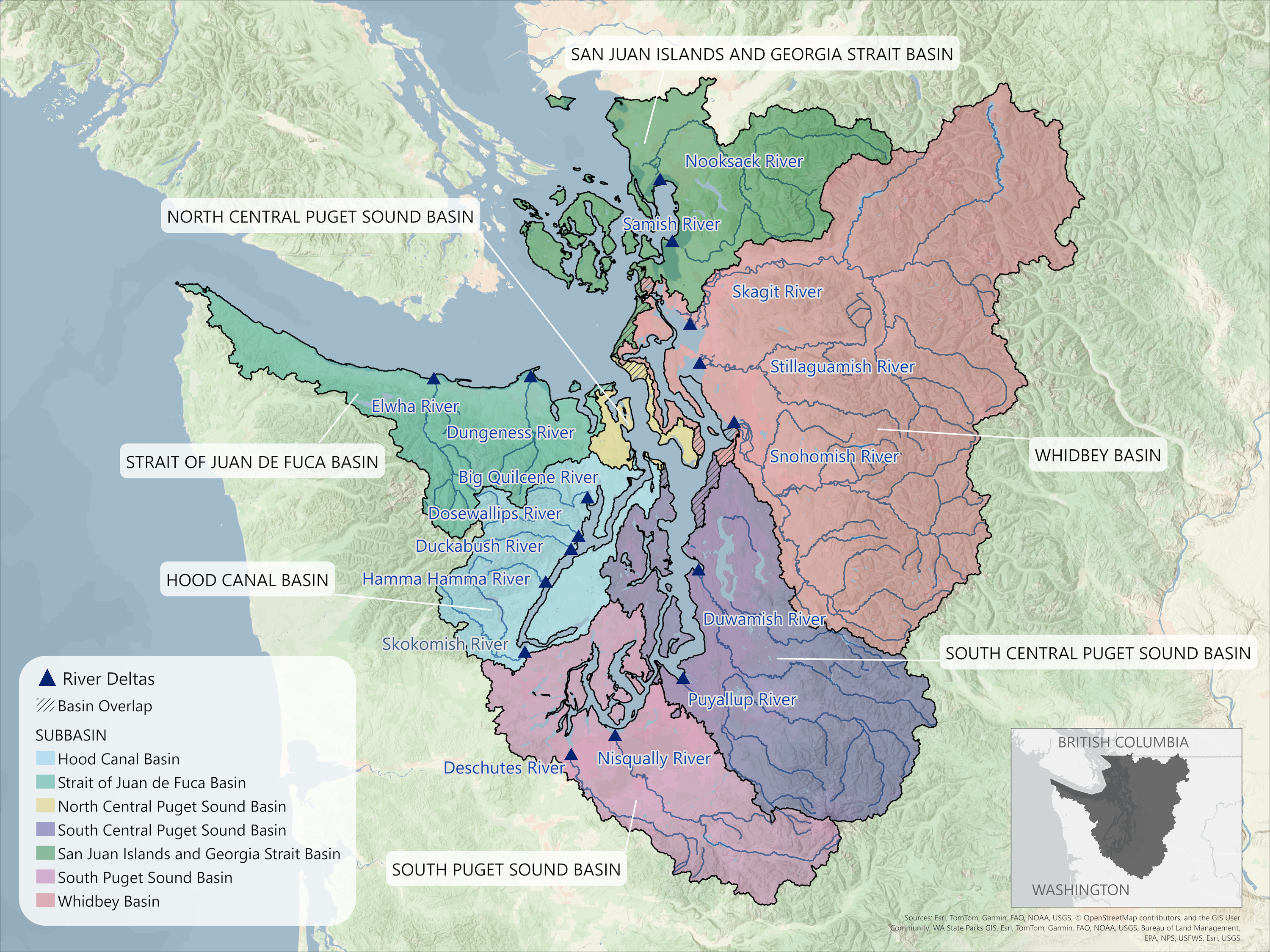
In this article, we present brief descriptions of the 16 major river deltas of Puget Sound ordered by subbasin from north to south (Figure 1). Much of the information is sourced from a comprehensive analysis of changes to Puget Sound nearshore ecosystems since early industrial development conducted as part of the Puget Sound Nearshore Ecosystem Restoration Project (PSNERP) (Simenstad et al. 2011). Another primary source is a PSNERP report that uses degradation assessments to identify strategies for the protection and restoration of the nearshore environment (Cereghino et al. 2012).
While the PSNERP data remains the most comprehensive baseline, restoration efforts have continued actively across the region. We highlight recent restoration projects for specific deltas where available, providing examples of ongoing work since the original PSNERP analysis.
San Juan Islands & Georgia Strait subbasin
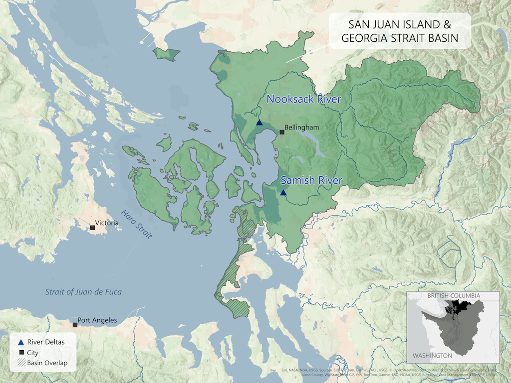
Nooksack River Delta
The Nooksack River flows from Mt. Baker and enters into the San Juan Islands and Georgia Strait subbasin of Puget Sound via Bellingham Bay. Three forks of the Nooksack River combine to flow into the 4th largest river delta in Puget Sound (Cereghino et al. 2012). The Nooksack River Delta, which is in the territory of the Lummi Nation, has lost 71% of its vegetated tidal wetlands and 47% of its shoreline length since the late 19th century (Simenstad et al. 2011). Both the Nooksack and Indian Tribe and the Lummi Nation depend on the Nooksack River and its delta which provides important salmon habitat. The two tribes are working to restore habitat for Spring Chinook along the South Fork of the Nooksack (NOAA Fisheries, 2024). The Lummi Nation is also working to protect tidal wetlands in the Nooksack River Delta Waldo et al. 2021. No part of the river is currently impounded behind dams which makes it popular for white water paddling and kayaking (Simenstad, 2011; American Rivers, 2024b). In the past, the river alternated between emptying into Bellingham Bay and flowing into Lummi Bay via the Lummi River.
Samish Bay
The Samish River drains an area between the Nooksack River basin to the north and the Skagit River basin to the south and empties into the in the San Juan Islands and Georgia Strait subbasin via Samish Bay. Samish Bay has lost 97% of its vegetated tidal wetlands and 58% of its shoreline length (Simenstad et al. 2011). Samish bay is crucial for fish and shellfish production where tide flats are farmed for oysters, clams, mussels, and geoduck. It also supports coho, chum, steelhead, and cutthroat and hatchery produced fall Chinook.
Whidbey subbasin
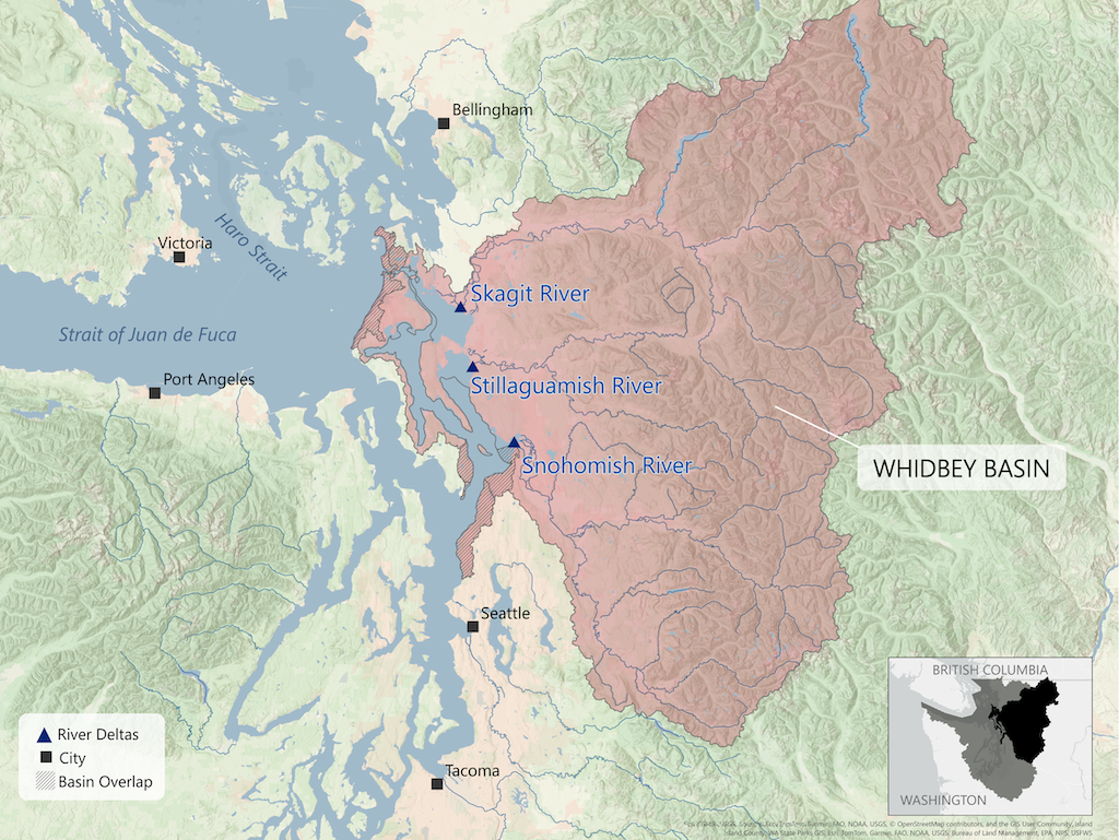
Together, the Skagit, Stillaguamish, and Snohomish deltas of the Whidbey sub-basin account for 70 percent of all historical delta wetlands in Puget Sound (Cereghino et al. 2012).
Skagit Bay
The Skagit River originates in the Cascade Mountains and drains into the Whidbey subbasin of Puget Sound via Skagit Bay which is the largest river delta in Puget Sound. Skagit Bay has lost 74% of its vegetated wetlands and 45% of its shoreline length (Simenstad et al. 2011). The Skagit River basin includes mountains, valleys, and floodplains and supports one of the richest agricultural areas in the world. Three major dams (Ross, Diablo, and Gorge) built primarily for hydropower along the Skagit, currently block the passage of salmon upriver. Levees and dikes also limit river flows, which causes sediment to build up at the mouths of the north and south forks of the Skagit River.
The Skagit River estuary support all eight species of salmonids of Puget Sound including pink, chum, sockeye, coho , Chinook salmon, coastal cutthroat trout, steelhead trout, and bull trout (Quinn, 2024).
Stillaguamish River
The Stillaguamish River is the fifth largest tributary to Puget Sound and is one of a few major rivers that is unimpeded by dams, ideal for salmon and steelhead runs. However, historical diking of the river delta has resulted in the loss of tidal wetlands (Simenstad et al. 2011). Additionally, sedimentation from landslides has furthered degradation. The Stillaguamish River delta has lost 69% of its vegetated wetlands and 22% of its shoreline length (Simenstad et al. 2011). Efforts to restore delta habitat include the Nature Conservancy’s Port Susan Bay project and the Stillaguamish Tribe’s Zis a ba restoration project.
Snohomish River
The Snohomish River delta is the second largest in Puget Sound. It has lost 90% of its vegetated tidal wetlands and 37% of its shoreline length (Simenstad et al. 2011). A series of large scale restoration projects aim to reestablish areas of tidal inundation within the lower delta and will result in the largest estuary restoration area in Puget Sound when completed. The Snohomish River is located in the usual and accustomed harvest areas of the Tulalip Tribes of Washington with portions within the tribal reservation.
South Central Puget Sound subbasin
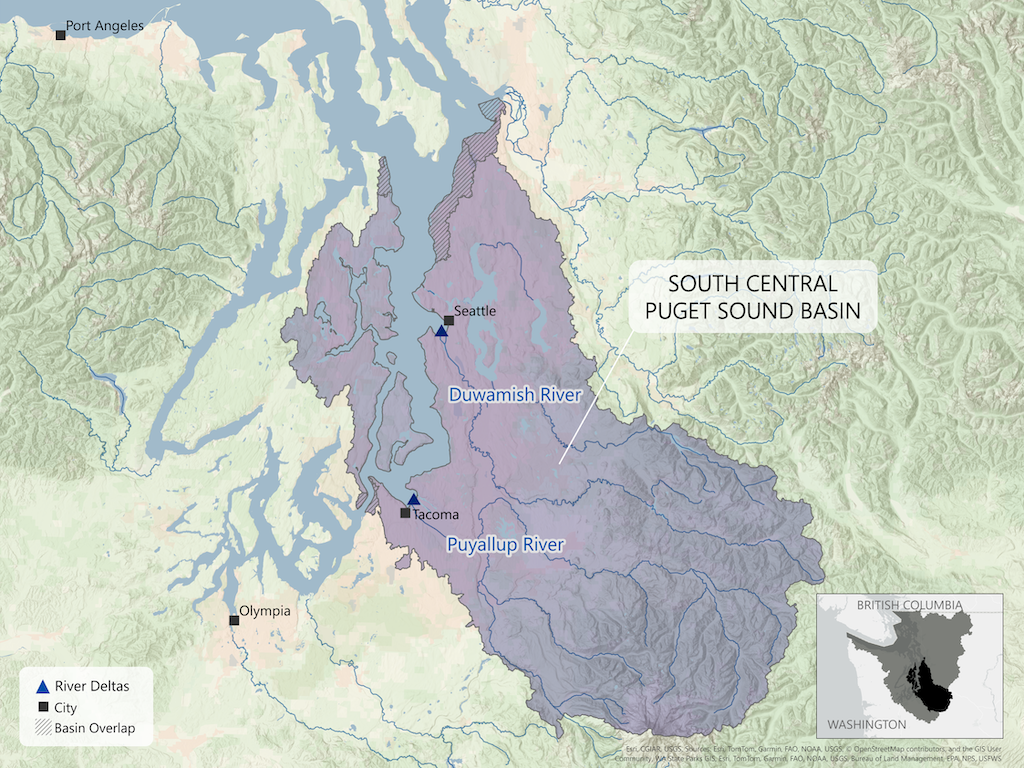
Duwamish River
The Duwamish River feeds into an industrial estuary in the Port of Seattle known as the Duwamish waterway. The delta, the ninth largest (Cereghino et al. 2012), has lost all of its vegetated tidal wetlands and shoreline length (Simenstad et al. 2011), making it the most degraded river delta in Puget Sound (Cereghino et al. 2012)The river flows through the largest warehouse district on the west coast resulting in 100% of the shoreline having some sort of infrastructure development. The river also contains the Howard Hanson Dam, which has no passage for salmon to travel through. Further down river, Tacoma Water’s diversion dam contains an adult fish passage system (American Rivers, 2024a).
Puyallup River
The Puyallup River contains the second most degraded delta in Puget Sound, having lost 100% of both its vegetated tidal wetlands and shoreline length (Simenstad et al. 2011). The lower river is located primarily in the Puget Sound lowlands, reaching a maximum elevation of 50 ft above sea level (Department of Ecology, 2024). The Washington Department of Ecology has flagged the river for a range of water quality issues, including pH, sediment, and temperature (Department of Ecology, 2024). These parameters will all affect the survival of salmon and other wildlife in the river. The Puyallup tribe is involved in salmon restoration projects that involve rebuilding salmon populations through hatcheries in the Puyallup basin.
South Puget Sound subbasin
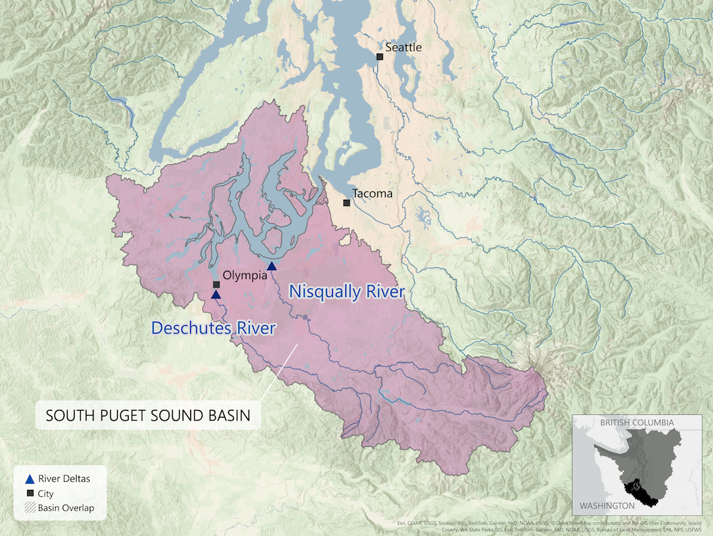
Nisqually River
The Nisqually River delta embodies the largest tidal marsh restoration project in the Pacific Northwest. However, it has lost 77% of its historical vegetated tidal wetlands and 68% of its shoreline (Simenstad et al. 2011) The Alder Dam impounds sediment upriver, and the Nisqually Refuge dike and I-5 causeway restrict salmon movement up and downstream (Czuba, 2012). The Nisqually tribe plays a significant role in restoration efforts within the river and delta. The headwaters of the river are in Mount Rainier National Park and the delta is located in the Billy Frank Jr National Wildlife Refuge.
Deschutes River
The Deschutes River in South Puget Sound (not to be confused with the Deschutes River in central Oregon) joins the Sound at Budd Inlet in the city of Olympia. The Deschutes River Delta has lost 50% of its shoreline length (Simenstad et al. 2011) . The mouth of the river was dammed in 1951 to create Capitol Lake as a reflecting pool below the Washington State Capitol (PSNERP, n.d.). Capitol Lake contains more sediment than the historical delta due to a lack of tidal exchange. In 2024, the Squaxin Tribe received a federal grant to remove the 5th Avenue dam, an active barrier to salmon migration (The Olympian, 2024).
Hood Canal subbasin
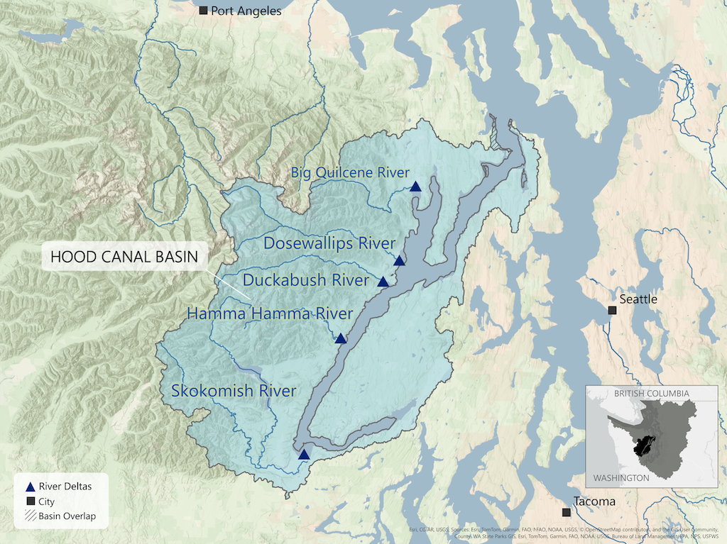
Skokomish River
The Skokomish River, which has the largest delta in the Hood Canal subbasin(Cereghino et al. 2012), has lost 56% of its historical shoreline length but none of its vegetated wetlands (Simenstad et al. 2011). The Skokomish Indian Nation has worked with the local, state, and federal governments on the restoration of the Skokomish River basin, and restoration of the river delta is the most complete estuary restoration in Puget Sound (NOAA Fisheries, 2019). Two years after the restoration was completed in 2014, the Skokomish Indian Nation reintroduced Chinook salmon to the river, and the fish returned in 2018, officially marking the return of Chinook salmon to the Skokomish watershed (NOAA Fisheries, 2019).
Hamma Hamma River
The Hamma Hamma River on the Olympic Peninsula has one of Puget Sound's least degraded major river deltas. Of the 16 major river deltas of Puget Sound, Hamma Hamma is also one of the smallest (Cereghino et al. 2012). It has lost 34% of its shoreline length and none of its vegetated wetlands (Simenstad et al. 2011) . The river itself flows freely (without dams) from high elevation lakes in the Olympic Mountains to the Sound.
Duckabush River
The Duckabush River has lost 43% of its shoreline but none of its vegetated wetlands (Simenstad et al. 2011). In 2015, the Jefferson Land Trust acquired 140 acres of riverbank and forest land, to help protect and conserve known salmon spawning grounds of the river.
Dosewallips River
The Dosewallips River, located partially within Olympic National Park, has lost 48% of its shoreline length but none of its vegetated wetlands (Simenstad et al. 2011). Structures and marinas cover close to 50 percent of the aquatic area on the southern edge of the Dosewallips River delta (Simenstad et al. 2011). The Jefferson Land Trust has been involved in conservation of the Dosewallips River since 1994.
Quilcene Bay
Quilcene Bay is the 12th largest delta out of 16 systems in Puget Sound (Cereghino et al. 2012). The bay has lost 53% of its historical shoreline length but none of its vegetated wetlands (Simenstad et al. 2011). None of the Quilcene River watershed is currently impounded behind dams. Quilcene bay supports a variety of shellfish including Manila clams, littleneck clams, eastern softshell clams and oysters. The Hood Canal Salmon Enhancement Group has completed several restoration projects.
Strait of Juan de Fuca subbasin
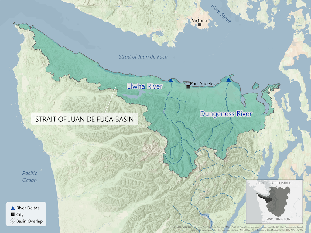
Dungeness Bay
Dungeness Bay has lost 30% of its vegetated tidal wetlands and 51% of its shoreline length (Simenstad et al. 2011) . The Dungeness River basin is located in a rain shadow on the East side of the Olympic Mountains. Lack of rain severely dries out the river valley, especially in the late summer months, affecting salmon and people. In the 1850s, close to 8,000 salmon returned annually to the river system; that number has dropped to 200–900 salmon annually (Washington Water Trust, n.d.). The Dungeness Water Exchange was created by local tribes, government, and residents to address water shortages in 2013. The Washington Department of Ecology has capped the amount of water from the basin that is available for out-of-stream uses (Washington Water Trust, n.d.). When new water needs arise, water must be reallocated from within the water bank, to ensure that stream flows are maintained. Plans for an off-channel reservoir to collect water during high flow season and store it for use during drought season are underway.
Elwha River
Removal of the Elwha Dam and the Glines Canyon Dam has helped make the Elwha River delta the least degraded in Puget Sound, according to PSNERP (Cereghino et al. 2012) . The delta lost 25% of its historical shoreline length but now has 100% of its historical vegetated wetlands (Simenstad et al. 2011). The Elwha represents the second largest dam removal project in US history, (superseded only recently by dam removal on the Klamath River along the Oregon and California border) (American Rivers, 2024c). Following the return of native vegetation to the Elwha River delta, salmon and other wildlife have been seen in the river again. The Lower Elwha Klallam tribe is removing dikes along the river as restoration continues.
References
American Rivers. (2024a). Green Duwamish River. Retrieved November 2024, from American Rivers: https://www.americanrivers.org/river/green-duwamish-river/
American Rivers. (2024b). Nooksack River. Retrieved November 2024, from American Rivers: https://www.americanrivers.org/river/nooksack-river/
American Rivers. (2024c). Elwah River: (Re)Born to be wild. Retrieved November 2024, from American Rivers: https://www.americanrivers.org/river/elwha-river/
Cereghino, P. J. et al. (2012). Strategies for nearshore protection and restoration in Puget Sound. Puget Sound Nearshore Report No. 2012-01. Seattle, Washington: Washington Department of Fish and Wildlife Olympia, Washington, and the U.S. Army Corps of Engineer.
Czuba, J. O. (2012). Changes in sediment volume in Alder Lake, Nisqually River Basin, Washington, 1945–2011. USGS.
Department of Ecology. (2024). Puyallup River basin TMDLs. Retrieved November 2024, from Water quality improvement projects: https://ecology.wa.gov/water-shorelines/water-quality/water-improvement/total-maximum-daily-load-process/directory-of-improvement-projects/puyallup
Lead Entity Salmon Recovery Portal. (2016). Samish River. Retrieved November 2024, from https://srp.rco.wa.gov/project/280/1587
NOAA Fisheries. (2019). Skokomish River Watershed. Retrieved November 2024, from NOAA Fisheries: https://media.fisheries.noaa.gov/dam-migration/skokomish_watershed_factsheet_final_05-17-2019.pdf
NOAA Fisheries. (2024, August 26). Washington Tribes Restore Salmon Habitat on South Fork Nooksack River. Retrieved from https://www.fisheries.noaa.gov/feature-story/washington-tribes-restore-salmon-habitat-south-fork-nooksack-river
PSNERP. (n.d.). Puget Sound Nearshore Ecosystem Restortation Project. Retrieved November 2024, from Deschutes River Estuary: https://des.wa.gov/sites/default/files/2022-06/PSNERP-DeschutesRiverEstuarySummary.pdf
Quinn, T. P. (2024). The role of estuaries in the ecology of adult Pacific salmon and trout. Tacoma, WA: Puget Sound Institute, University of Washington Tacoma.
Salish Sea Restoration. (2014). Puyallup Delta. Retrieved November 2024, from Salish Sea Restoration Wiki: https://salishsearestoration.org/wiki/Puyallup_Delta
Simenstad, C. M. et al. (2011). Historical Change of Puget Sound Shorelines: Puget Sound Nearshore Ecosystem Project Change Analysis. Puget Sound Nearshore Report No. 2011-01. Seattle, Washington: Washington Department of Fish and Wildlife, Olympia, Washington, and U.S. Army Corps of Engineers.
The Olympian. (2024, May 24). Squaxin tribe gets federal grant to remove 5th Avenue Dam. Nisqually project funded too. The Olympian.
Waldo, T. et al. (2021). 2020 State of Our Watersheds. Lummi watershed. A Report by the Treaty Tribes in Western Washington.
Washington Water Trust. (n.d.). Dungeness River. Retrieved Novmember 2024, from Washington Water Trust: https://www.washingtonwatertrust.org/projects/dungeness-river/
Wildlife Management Institute. (2024, June). Preserving Puget Sound’s Estuarine Habitats. Outdoor Bulletin., 78(6).