Like many others in Whatcom County and elsewhere, when Althea Wilson first heard the reports and saw the dramatic images of Nooksack River flooding last year, she worried for the people who had lost homes and livelihoods, and whose physical safety was threatened.
But she also had a more unusual reaction: “Please don't blame the river,” she thought.
Wilson, a Lummi tribal member and Native Environmental Science curriculum coordinator at Northwest Indian College in Bellingham, completed an oral history project about life on the Nooksack River in 2018. Her interviews with tribal elders revealed a waterway that was rich in resources and contributed to a thriving Indigenous community that some outsiders dismissed as “river rats.”
The river, too, has been misunderstood, Wilson thinks. “It makes a lot of contributions to the Salish Sea that people really tend to overlook,” she says. “The only time that it gets any attention is when it so-called rears its ugly head to flood every so often.”
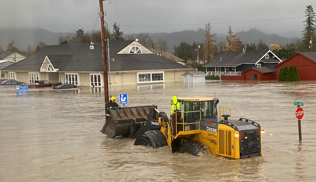
That’s what happened in November 2021, when intense rainfall from a series of atmospheric rivers loaded with water vapor from the tropics caused the river to overflow its banks, destroying homes, killing livestock, blocking roads, and damaging infrastructure in northern Whatcom County communities such as Everson, Nooksack, and Sumas. Waters from the river also contributed to historic flooding in Sumas Prairie and Abbotsford, British Columbia.
Periodic flooding has long been a pattern along the Nooksack River, as Wilson’s interviews with tribal elders showed. “They talked about the flooding as if it was just another fact of life,” she says.
Particularly in the late fall, heavy snowfall at low elevations followed by warmer temperatures and rainfall that melts the snow can send a massive surge of water raging down the Nooksack, which runs for 75 miles from Mount Baker to Bellingham Bay. “Those types of hydrologic events are natural in our watershed, they're just happening more frequently and have greater magnitude due to climate change,” says Oliver Grah, water resources manager for the Nooksack Indian Tribe.
Climate change means more intense rains, and more precipitation that falls as rain rather than snow – which runs off more quickly. Land use change exacerbates the problem: clearcuts in the upper Nooksack watershed compact the soil and remove mature forests that could effectively soak up moisture. Clearing and development of riparian forests in the lowlands has further reduced the buffer against flooding.
Shifting boundaries
The Nooksack is a short river with a complex story. It was once a tributary of the Fraser River, but at some point – perhaps a few thousand years ago, perhaps a few hundred – it abruptly shifted course.
“The lower extent of the Nooksack River is really part of the Fraser River delta,” Grah says. Over geologic time, the Fraser “has reworked and worked” a wide swath of territory between the North Shore Mountains north of Vancouver, BC and the Chuckanut Mountains south of Bellingham. Today, a ramrod-straight international border runs through this shifting landscape.
Although the Nooksack’s present-day channel never enters Canada, a portion of the river’s 790-square-mile watershed lies north of the border. Three major tributaries of the Nooksack, Bertrand Creek, Pepin Brook, and Fishtrap Creek, originate in Canada. And when the Nooksack overtops its banks – especially around the town of Everson, which is thought to be the site of the avulsion, or shift in the river’s course – its waters seek their former pathway to the sea.
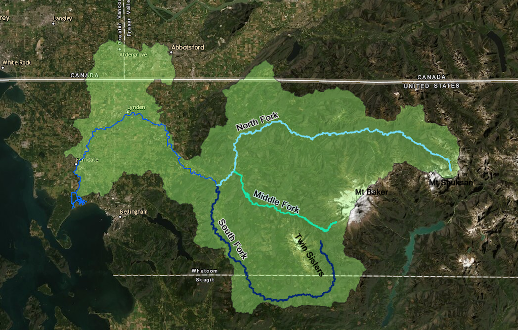
Three forks and the main stream of the Nooksack River. Light green shows the river drainage areas, some of which reaches into British Columbia. Source: Arcgis storymap
These interlinkages have prompted efforts at cross-border collaboration to manage flood risks. A Nooksack River International Task Force was launched after severe floods that also affected Canada in 1990. Staff turnover and funding interruptions have resulted in only intermittent engagement and fitful progress, but November's flooding may mark a turning point. On March 15, British Columbia Premier John Horgan and Washington Governor Jay Inslee announced plans for a transboundary flood prevention initiative, with further details to be rolled out later in the spring.
Such collaborations are not without precedent, including those among U.S. and Canadian scientists who have worked together on other river management issues. In mid-2021, the Nooksack River Transboundary Technical Collaboration Group completed a three-year effort to address bacterial contamination in the watershed. Animal waste from agricultural operations on both sides of the border contributes to harmful levels of enteric bacteria such as E. coli in the river, which has resulted in periodic closures of shellfish harvesting in Bellingham Bay. “Information sharing is very successful” across the border, says James Kardouni, a water quality scientist with the Washington Department of Ecology.
Digging in
In the wake of last year’s floods, much public discussion in both Canada and the U.S. has focused on the possibility of dredging the bed of the Nooksack River to provide more space for floodwaters to flow within the river channel.
The Nooksack contributes more sediment per square mile of basin than any other river that drains into Puget Sound – a total of 1.4 million tons per year. The reasons for this are, again, a combination of natural forces exacerbated by land use and climate change. Volcanoes such as Mount Baker where the headwaters of the Nooksack originate have a sandcastle-like quality. They’re made of what geologists call “unconsolidated material,” which is easily eroded and transported into waterways.
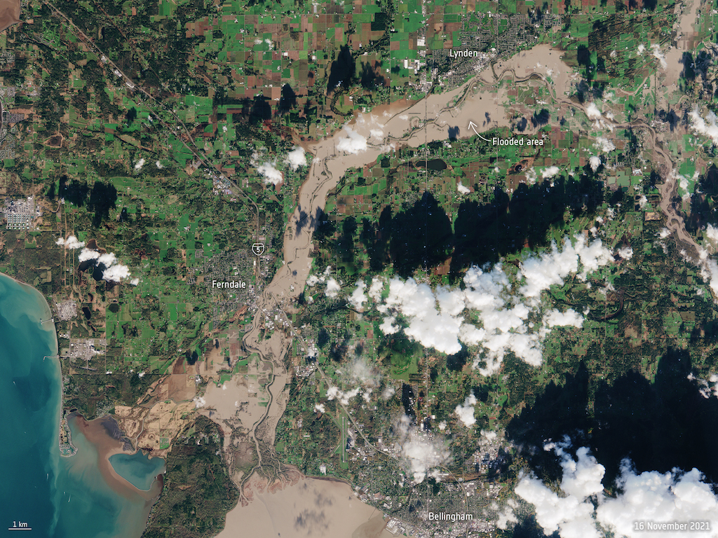
A satellite image shows the extent of flooding in the Nooksack River in November 2021 following an atmospheric river, a huge plume of moisture extending over the Pacific and into Washington. Image: European Space Agency (CC BY-SA 2.0)
Bare soil left behind by clearcutting and by glaciers receding due to climate change further ups the potential for erosion. And heavier rains and more forceful streamflow – again the consequences of climate change – result in a river with greater capacity to transport sediment, which then settles out as the river slows down in low-lying areas. Meanwhile, human-built infrastructure such as bridges creates “pinch points” where the river drops sediment, exacerbating flooding at those locations.
Many researchers and people involved in flood management say that the Nooksack’s own natural features and processes – including the sediment that others want to remove – provide the solution to the problem of floods like those that occurred last November.
For half a century ending in the late 1990s, gravel was commercially mined from the Nooksack River. Some residents affected by last year’s floods invoke that history to argue that dredging gravel from the riverbed now would be a straightforward solution to lower the river level and help protect their homes and fields from flooding. They’re particularly focused on a recent accumulation of sediment around Everson, where the river jumped its banks last fall.
Riverbed gravel is prime spawning habitat for salmon in the South Fork Nooksack River. Photo: USDA/NRCS
But others say it’s not that simple. At best, it’s a temporary solution. “You can dig it out at a given location, but it will fill back in, that's what the river is going to do,” says Scott McKinney of the Washington State Department of Ecology. “So you're in this sort of endless loop.”
What’s more, dredging the channel at one location can make floodwaters all the fiercer for those located downstream (and, of course, fiercer floodwaters have more capacity to transport sediment). And dredging is environmentally destructive. Riverbed gravel is prime spawning habitat for salmon, including threatened Chinook. While dredging the Nooksack hasn’t been categorically ruled out by managing agencies, both the Nooksack Indian Tribe and the Lummi Nation have raised concerns about the potential effects on salmon, and any dredging proposal could run afoul of the Endangered Species Act.
Instead, many researchers and people involved in flood management say that the Nooksack’s own natural features and processes – including the sediment that others want to remove – provide the solution to the problem of floods like those that occurred last November.
“Proposals to dredge the river would actually be eliminating a solution to the problem,” says John McLaughlin, an environmental scientist at Western Washington University in Bellingham. The pores in between pieces of gravel represent a natural flood control system, he explains. “Gravel, both in the river and just immediately adjacent to the river where the floodwaters would go, stores water” and slows its release downstream.
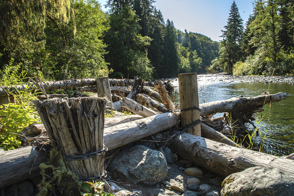
An engineered log jam installed in South Fork Nooksack River. Photo: USDA/NRCS
But the Nooksack’s natural sediment dynamics have been upended, McLaughlin argues, because the massive logjams that are typical of Pacific Northwest rivers have been removed. Logjams also work to increase the water storage capacity of rivers, by creating pools and encouraging the buildup of water-holding gravel behind them.
McLaughlin adds that restoring the natural dynamics of gravel and logjams would not only mitigate flooding, but also address another of the major environmental concerns on the Nooksack: low flows and high water temperatures during the dry season. This, too, is a problem that is worsening with climate change, and one that threatens salmon. Last September, thousands of critically endangered Chinook salmon died in the South Fork Nooksack River due to exposure to warm water, low water levels, and bacteria.
Natural infrastructure
A major source of support for flood control projects that make use of this sort of natural infrastructure is Floodplains by Design, a Washington Department of Ecology program in collaboration with the Nature Conservancy and the Puget Sound Partnership. Floodplains by Design promotes what researchers call “integrated floodplain management,” meaning projects that offer multiple benefits such as both flood protection and habitat restoration, says Tom Buroker, the Department of Ecology’s Northwest regional director.
Most flood-control initiatives are planned and carried out at the county level. Whatcom County’s local flood management process is known as Floodplain Integrated Planning, or FLIP. This effort involves more than 100 stakeholders including representatives from federal, state, and local agencies; diking, drainage, and watershed improvement districts; agricultural interests; salmon recovery advocates; tribes; local cities; and others, says Paula Harris, the county’s river and flood manager. Whatcom County has received a total of $16 million in Floodplains by Design funding since 2013. (This does not account for all of the county's flood management activities, however.)
Among the flood mitigation measures most commonly employed by Floodplains by Design are levee setbacks. Much of the lower Nooksack River, from Everson to Puget Sound, is contained within levees, which in the past were built as close as possible to the riverbank. That practice eliminated floodplain habitat behind the levee, which scientists now understand is important for salmon recovery. Close-in levees can also intensify flooding for communities downstream. Building a new levee farther away from the riverbank (and removing the old one) allows floodwaters to spread out horizontally and slow down, providing “a way to reduce the flood hazard for the community in that area and benefit salmon habitat at the same time,” McKinney says.
However, last year’s floods on the Nooksack highlight the need for more funding for such projects, says McKinney, who administers Floodplains by Design’s grants process. Floodplains by Design funds much larger flood control efforts than other programs of its type, but comprehensively addressing the threat of flooding on the Nooksack River will require an even larger commitment, he argues.
Whatever the approach, managers say, planning will require coordinating and integrating efforts on all parts of the river — including Canada — something that has at times sparked controversy.
One possibility that has recently emerged is for the U.S. Federal Emergency Management Agency to declare lands north of Everson as a floodway. Some media reports have characterized this as an effort to funnel floodwaters north of the border; in fact, the designation would buy out existing homes and prevent future development, U.S. authorities say, ensuring that the land would be available to soak up floodwaters and prevent them from reaching Canada.
“The things that the county would do for flood protection” – that is, to protect Whatcom County communities like Everson and Sumas – “would also improve the situation for the cross-border flooding,” Ecology's Buroker says.
As debate continues on both sides of the border, a comprehensive and nature-focused approach to flood management on the Nooksack appears to be far from certain. But some say it reflects a radically different and perhaps, in the end, more effective way of living with the river. “We moved into its natural way of being. It didn't move into ours,” Wilson says of the Nooksack. “Why can't it thrive too?”

Story text available under a Creative Commons Attribution-NonCommercial-NoDerivs license: CC BY-NC-ND 4.0.