

Marine circulation in Puget Sound
Circulation overview
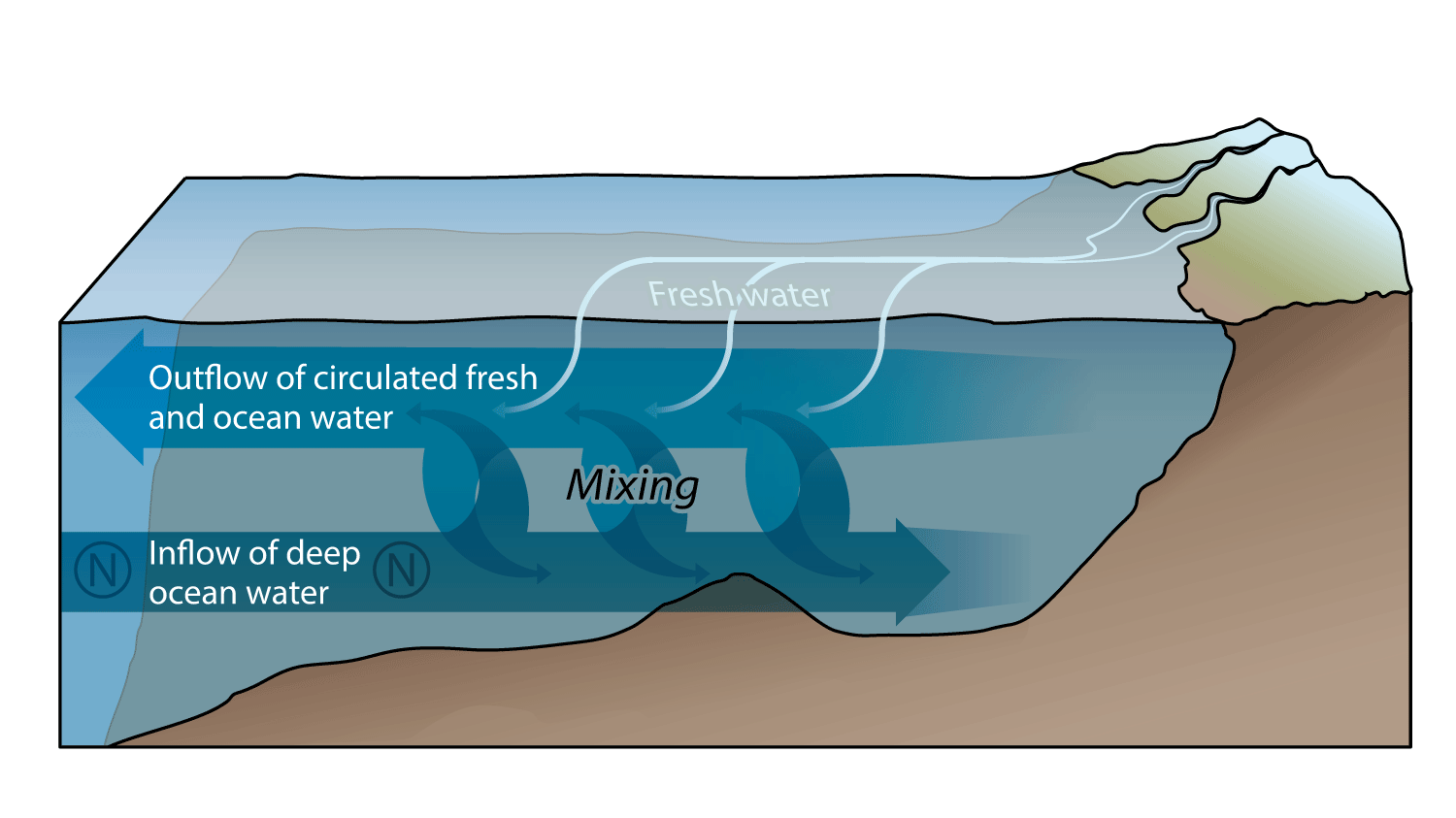
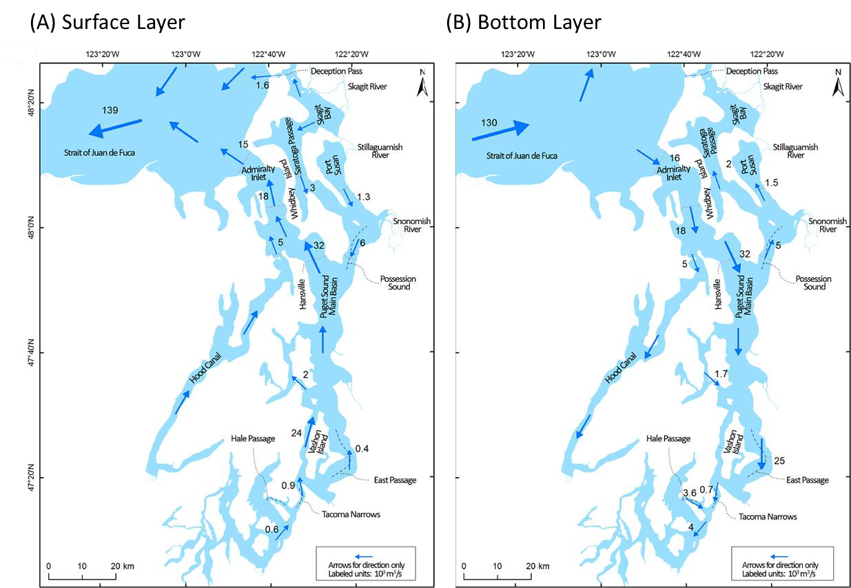
There are several key characteristics of marine circulation in the Salish Sea. The freshwater discharged by the major rivers and streams creates a stratified, two-layer circulation system. The upper layer, which ranges from approximately 0-30 m in depth depending on location within the system, consists of the seaward flow of fresh/brackish water. The depth of the surface layer, and strength of stratification, varies over the course of the year. The deep, lower layer consists of the landward flow of saline water in from the Strait of Juan de Fuca (Ebbesmeyer and Barnes, 1980; Khangaonkar et al., 2017; Khangaonkar et al., 2011; Sutherland et al., 2011).
Another major feature affecting circulation throughout the Puget Sound, and within specific sub-basins, is the existence of predominant sills, particularly those located at the Admiralty Inlet and the Tacoma Narrows. The area between these sills defines the Puget Sound Main Basin, with the Tacoma Narrows sill separating the Main Basin from the South Sound. The sills promote vertical mixing and result in surface layer reflux, where a fraction of the outflowing surface layer flows downward, combines with the bottom layer, and returns landward. At the Admiralty sill, approximately 60% of the surface flow is re-entrained into the bottom water and returns back into the Main Basin (Ebbesmeyer and Barnes, 1980; Khangaonkar et al., 2017).
Planar views of the circulation patterns in the surface layer and the bottom layer are shown in Figure 1A and 1B, respectively.
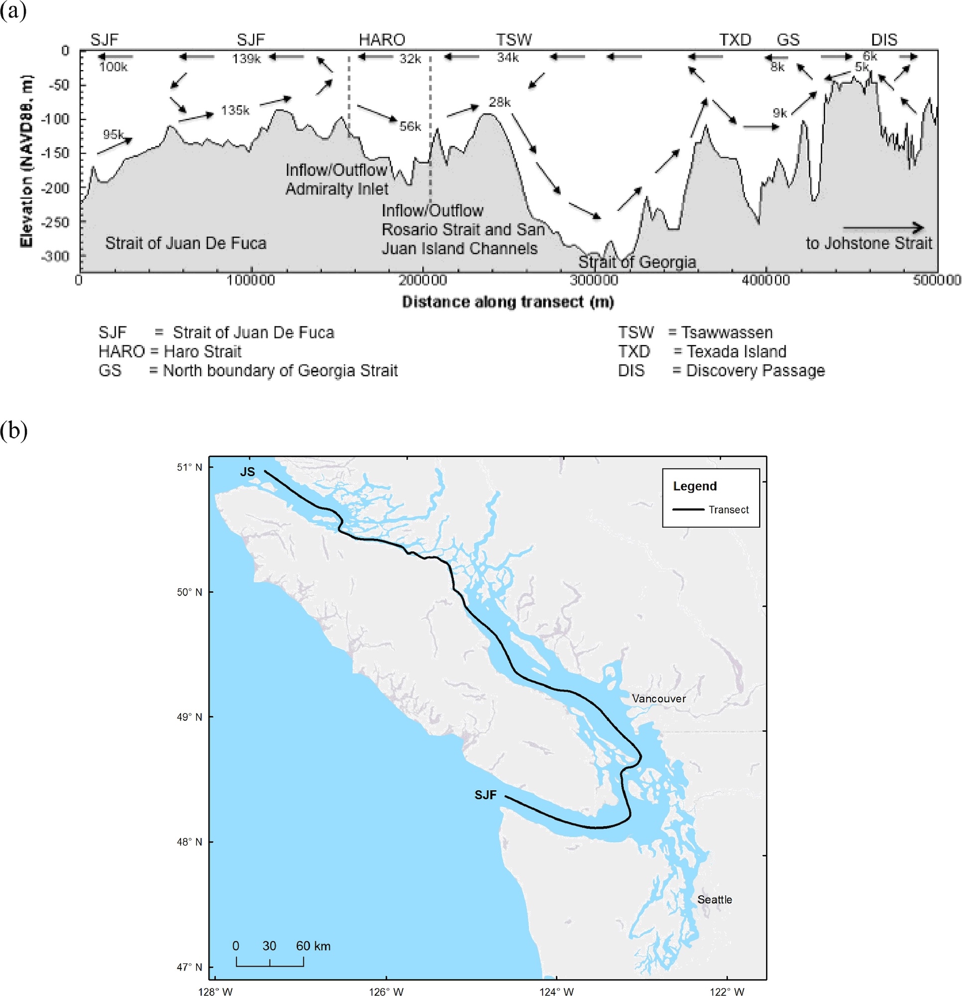
The depth profile of flows along a transect from the Pacific Ocean to South Puget Sound is shown in Figure 2.
The Puget Sound Model was built in the early 1950s by John H. Lincoln and Clifford Barnes of the UW School of Oceanography to better illustrate and study circulation. The Puget Sound Model: Tides and Currents” video provides an illustrated description of circulation and an overview of flows and current patterns.
Assimilative capacity and residence times
The assimilative capacity of a water body is the amount of a contaminant that could be put into that same water body without resulting in a deleterious change of condition, or a biological impact (Krom, 1986). This concept acknowledges the fact that minor inputs, and in this particular case minor inputs of anthropogenic nutrients, may have no observable effects on a marine ecosystem. This notion is also acknowledged in the Marine Water Quality indicator target of ΔDO<0.2 mg/L (where Δ = change) as it states that anthropogenic nutrient inputs from sources such as wastewater treatment systems and surface water runoff are acceptable so long as there are no predicted (or observed) changes in dissolved oxygen in Puget Sound greater than 0.2 mg/L. Therefore, the target sets the acceptable limit on inputs.
The assimilative capacity of anthropogenic nutrients in Puget Sound is not static and depends largely on the rate of flushing in the different basins and sub-basins. A system with a high rate of flushing can assimilate a larger nutrient load compared to the same system with a low rate of flushing. Flushing varies seasonally and annually. One way to measure the rate or magnitude of flushing, and thus the assimilative capacity, is with residence time.
The amount of time a parcel of water takes to leave a defined area, or region is called the residence time (Monsen et al., 2002). The residence times of water in the Puget Sound vary markedly by basin and sub-basin, with additional variation due to season, weather, winds, etc. But an averaged measure of residence time in a basin is useful in understanding potential impacts of nutrient addition on water quality. The residence time of a basin matters because it can influence water quality, and in particular the dissolved oxygen levels in the estuarine system.
The relationship between residence time and water quality can be informed by reviewing a few important processes. First, and as described above, marine water enters Puget Sound from the Pacific Ocean, through the bottom layer of Strait of Juan de Fuca, and into the greater Puget Sound at Admiralty Inlet. The quality of the bottom water, including the levels of dissolved oxygen, that enters the system generally reflects that of the Pacific Ocean at the entrance to the Strait of Juan de Fuca. Note that the levels of dissolved oxygen in the marine water at the mouth of the Strait of Juan de Fuca vary; status and trends are presented in Section 2.4.
Second, due to stratification between the surface layer and the bottom layer, mixing and oxygen transport between the two layers is limited. This means that atmospheric oxygen from the surface, or oxygen produced through primary production in the surface layer, will not necessarily diffuse downward from the surface layer into the bottom layer. Furthermore, the bottom waters may have seasonally different circulation and longer residence time than surface waters. Note that the magnitude of phytoplankton blooms varies according to nutrient availability; this is discussed more in Section 3.
Third, organic particles (phytoplankton, leaf detritus, etc.) can sink downward from the surface layer into the bottom layer. These organic particles are degraded through aerobic microbial processes which utilize oxygen. This biological oxygen demand is met by the dissolved oxygen in the bottom water resulting in oxygen depletion. The magnitude of the depletion depends on the flux of organic carbon entering the bottom waters and the volume of water entering the system. The volume of water can be measured by the residence time in a basin. The relationship of water influx, residence times, and assimilative capacity is summarized below.
- More water entering system → faster transport → shorter residence times
- More water entering system → more oxygen → higher assimilative capacity → lower numeric depletion
- Less water entering system → slower transport → longer residence times
- Less water entering system → less oxygen → lower assimilative capacity → higher numeric depletion
Residence times – variation
Spatial variation
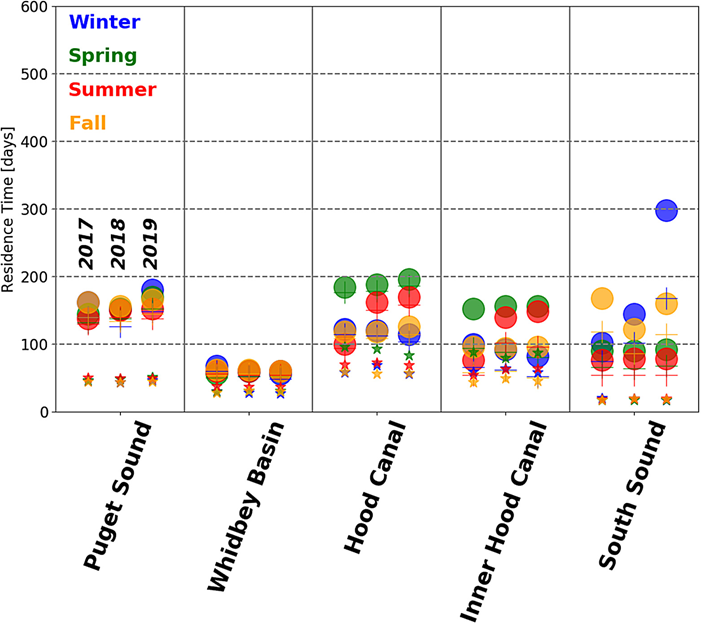
There is substantial variation between the residence times of the basins of the Puget Sound. Babson et al. (2006) utilized a box model to estimate the range of residence times and reported mean modeled residence times for the bottom water ranging from 37.8 days through the Main Basin to 87.7 days for the Hood Canal (modeled as northern Hood Canal and southern Hood Canal). The residence time is dependent on local and regional bathymetry and depth (i.e., sub-basin location relative to sills) and localized freshwater inputs, which suggests that basins and sub-basins will have a wide range of assimilative capacities. More recently, MacCready et al. (2021) utilized the LiveOcean model to study circulation and mixing in the Salish Sea, specifically quantifying efflux (water mixing upward into surface layer and then heading seaward) and reflux (water mixing downward into bottom layer and then heading landward). They reported that while the efflux and reflux markedly increased the average residence time of each of the basins, the relative difference in residence times between the basins was consistent with what was reported elsewhere. A summary of results is shown in Figure 4.
Temporal variation
The exchange flow into Puget Sound exhibits a strong annual cycle, with the annual flow maximum generally occurring in winter, though this varies each year (MacCready et al., 2021). The exchange flow may also be influenced by the salinity of water upwelled at the Pacific coast, which would affect the density gradient at the Strait of Juan de Fuca. Babson et al. (2006) reported that the variability in salinity, driven by tidal exchange, may account for more seasonal variability than river flows for most basins except for South Sound. Additional factors that may affect flows and residence times are the seasonal changes in wind patterns (Sutherland et al., 2011), tides (Deppe et al., 2018) and temperature that, along with salinity, influence density and can lead to density gradients that affect stratification and mixing regimes. Predicted seasonal residence times for Puget Sound and major sub-basins are shown in Figure 4.
Coastal ocean and Puget Sound boundary conditions
Water from the Pacific coastal shelf enters into the Puget Sound at the Strait of Juan de Fuca via Admiralty Inlet, and so the condition of the water at the ocean boundary can greatly influence water quality in Puget Sound. The Northwest Association of Networked Ocean Observing Systems (NANOOS) and the University of Washington (UW) maintain a large surface mooring (Ćháʔba) and an adjacent subsurface profiling mooring (NEMO-subsurface) to collect and record oceanographic and meteorological measurements on the Northwest Washington shelf. This system provides information on the boundary condition for Puget Sound. As reported annually in the PSEMP Marine Waters Overview reports, there are important inter- and intra-annual changes in the levels of DO in the marine waters, that could affect condition within the embayments of Puget Sound. This monitoring over time provides a measure of the variation in DO between calendar years (grey lines in Figure 5) and in a specific year (red and black lines in Figure 5). As shown, in 2018 the levels of DO in the deep water at Ćháʔba gradually decreased from May through mid-August and then transitioned into a series of episodic intervals of low dissolved oxygen or hypoxia, which is commonly defined as DO<2mg/L (Diaz and Rosenberg, 1995). The DO during these periods was occasionally below 0.25 mg/L. These episodic events are associated with northward-flowing bottom water, which is related to increased winds to the north. Changes in these wind patterns led to changes in current and DO conditions at the moorings.
Figure 5. Dissolved oxygen (DO) measurements at Ćháʔba at 85 m depth. Measurements for 2018 (red), 2017 (black) and 2011-2016 (gray) are shown, and describe annual trends and variation. Note wind-related episodic hypoxia events from mid-August through mid-October. Chart from Szuts et al. in PSEMP Marine Waters Workgroup (2019).
References
Babson, A.L., Kawase, M., MacCready, P., 2006. Seasonal and Interannual Variability in the Circulation of Puget Sound, Washington: A Box Model Study. Atmosphere-Ocean 44, 29-45.
Deppe, R.W., Thomson, J., Polagye, B., Krembs, C., 2018. Predicting Deep Water Intrusions to Puget Sound, WA (USA), and the Seasonal Modulation of Dissolved Oxygen. Estuaries and Coasts 41, 114-127.
Diaz, R., Rosenberg, R., 1995. Marine benthic hypoxia: A review of its ecological effects and the behavioral responses of benthic macrofauna. Oceanography and Marine Biology: An Annual Review 33, 245-303.
Ebbesmeyer, C.C., Barnes, C.A., 1980. Control of a fjord basin's dynamics by tidal mixing in embracing sill zones. Estuarine and Coastal Marine Science 11, 311-330.
Khangaonkar, T., Long, W., Xu, W., 2017. Assessment of circulation and inter-basin transport in the Salish Sea including Johnstone Strait and Discovery Islands pathways. Ocean Modelling 109, 11-32.
Khangaonkar, T., Yang, Z., Kim, T., Roberts, M., 2011. Tidally averaged circulation in Puget Sound sub-basins: Comparison of historical data, analytical model, and numerical model. Estuarine, Coastal and Shelf Science 93, 305-319.
Krom, M.D., 1986. An evaluation of the concept of assimilative-capacity as applied to marine waters. Ambio 15, 208-214.
MacCready, P., McCabe, R.M., Siedlecki, S.A., Lorenz, M., Giddings, S.N., Bos, J., Albertson, S., Banas, N.S., Garnier, S., 2021. Estuarine Circulation, Mixing, and Residence Times in the Salish Sea. Journal of Geophysical Research: Oceans 126, e2020JC016738.
Monsen, N.E., Cloern, J.E., Lucas, L.V., Monismith, S.G., 2002. A comment on the use of flushing time, residence time, and age as transport time scales. Limnology and Oceanography 47, 1545-1553.
PSEMP Marine Waters Workgroup, 2019. Puget Sound marine waters: 2018 overview, Moore, S.K., Wold, R., Curry, B., Stark, K., Bos, J., Williams, P., Hamel, N., Apple, J., Kim, S., Brown, A., Krembs, C., Newton, J. (Eds.). Puget Sound Ecosystem Monitoring Program, Tacoma, WA.
Sutherland, D.A., MacCready, P., Banas, N.S., Smedstad, L.F., 2011. A model study of the Salish Sea estuarine circulation. Journal of Physical Oceanography 41, 1125-1143.