

Background
Tidal wetlands are highly productive ecosystems that provide a variety of resources and ecosystem functions to Puget Sound biota and humans. In this report, tidal wetlands refer to both estuarine (intertidal) and riverine tidal (tidally-influenced freshwater) wetlands along the Puget Sound shoreline. Wetlands provide important ecosystem roles, directly regulating hydrologic and biogeochemical processes and supporing high rates of biological productivity (Mitsch and Gosselink 2007). They also are a key habitat for a suite of fish, amphibian, invertebrate and bird species including chum and Chinook salmon, herring, Dungeness crabs and Great Blue Herons (e.g., McMillan et al. 1995, Simenstad and Cordell 2000, Eissinger 2007 , Stick and Lindquist 2009). Because of the fjord-like topography in Puget Sound, tidal wetlands are predominantly associated with the major rivers. The steep, rocky bathymetry and topography limit the existence of extensive intertidal areas or the deposition of sediments on which vegetated wetland might occur (Boule 1981). Low gradient rivers combined with substantial tidal ranges create large intertidal areas in river floodplains that contain plant communities strongly controlled by a substantial amount of freshwater runoff. Tidal wetlands in Puget Sound have experienced significant losses and degradation as a result of development and other land uses.
Editor's note: Sections of this chapter are being amended to include information from the following documents published after the initial release of the Puget Sound Science Review.
Status
Collins and Sheikh (2005) characterized tidal wetland habitat across the sub-basins of Puget Sound (Figure 1) using both aerial and oblique photographs taken from 1998 – 2000 as part of a detailed study comparing the extent and nature of current and historical wetlands. They found that nearly half of the current tidal marsh area is in located in the Skagit, Stillaguamish and Samish river deltas and that the median size of a tidal wetland complex is 0.57 hectares (Figure 2)(Collins and Sheikh 2005). They estimate that there are currently 5,650 hectares of tidal wetland habitat in Puget Sound (Collins and Sheikh 2005). In a more detailed analysis of the composition of wetlands in river deltas, they found that the dominant type of tidal wetland in the river deltas of Puget Sound is currently estuarine-emergent wetland relative to the less frequent estuarine scrub-shrub and riverine habitat types (Figure 3)(Collins and Sheikh 2005).
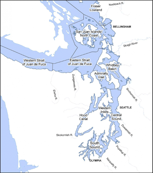
Figure 1. Sub-basins of Puget Sound as defined by Collins and Sheikh (2005). Reprinted with permission from Collins and Sheikh (2005).

Figure 2. Current area of individual wetland complexes (note: in all pie diagrams, wetland is proportional to the symbol area (reprinted with permission from Collins and Sheikh 2005)

Figure 3. Relative area of current tidal wetland types in the estuaries of major rivers draining the Cascade Range and Olympic Mountains. EEM- estuarine emergent wetland; ESS- estuarine scrub-shrub wetland; RT- riverine-tidal wetland. (note: in all pie diagrams, wetland is proportional to the symbol area) (reprinted with permission from Collins and Sheikh 2005)
Trends
Several quantitative investigations into the degree of alteration of tidal wetlands have been conducted in Puget Sound. The earliest and most comprehensive assessment of areal coverage of tidal wetlands occurred in the mid 1880s by a Snohomish resident for the purposes of assessing agricultural development potential (Nesbit 1885). This endeavor used navigation maps, interviews with residents, and field observations to document the extent of tidal marshes and swamps (inclusive of saltmarsh and freshwater marsh) throughout Washington State from ca.1883. It found that tidal marshes greatly exceeded tidal flats in area on Puget Sound and that freshwater marshes were three to four times as great in extent as compared to the tidal marshes. Based on this early surveying effort by Nesbit (1885) , Thom and Hallum (1990) estimated approximately 26,792 hectares of tidal wetlands in seven of the nine counties bordering Puget Sound in the late 1800s. As such, approximately 38% of tidal marshes in Puget Sound may have already been converted to agricultural and urban land uses by the late 1800s (Nesbit 1885, Collins and Sheikh 2005).
The historic extent of tidal wetlands in Puget Sound was also recorded on topographic charts known as “T-sheets,” which were produced by the U.S. Coast Survey and the U.S. Coast and Geodetic Survey in 1884-1908. A review of comparisons between the T-sheets and more current sources including U.S. Geologic Survey topographic maps (produced in the 1970s) was conducted by Thom and Hallum (1990). This effort also drew upon analyses by Bortelson et al. (1980) and Boule et al. (1983). This investigation revealed that the most substantial intertidal wetland losses occurred in the Snohomish, Duwamish and Puyallup river deltas, reported to have experienced loss of 32 %, 100%, and 99% respectively. Subaerial wetland loss (defined as those wetlands landward of the general saltwater shoreline, but exclusive of intertidal wetlands) was also significant, with total losses of approximately 73% in river deltas throughout Puget Sound since the late 1800s (Bortleson et al. 1980, Thom and Hallum 1990).
More recently, Collins et al. (2003) reconstructed historical environments of several estuaries in northern Puget Sound and concluded that a considerable amount of tidal wetland had already been converted to agricultural and other land uses prior to development of the T-sheets, particularly estuarine scrub-shrub and riverine tidal environments, which were the basis of previous studies. To provide a comprehensive assessment, the Washington Department of Natural Resources (WDNR) collaborated with the University of Washington (UW) to characterize the historic and current distribution, type, and amount of tidal wetlands in Puget Sound (2005). Collins and Sheikh (2005) used a number of other sources that supplemented and cross-referenced the T-sheets, including records of federal land survey, aerial photographs, the survey conducted by Nesbit (1885) and soil surveys. They developed an atlas of pre-settlement (mid 1880s) riverine and nearshore habitats consisting of a spatially explicit digital database based on a landform and process-based classification of nearshore wetlands (see Collins and Sheikh (2005) for a complete summary of methods and results). They estimated the historic area of wetland habitat in Puget Sound to be 29,500 acres, indicating that the current tidal wetlands are 17 – 19% of their historical extent (Collins and Sheikh 2005). They found that the Whidbey basin (which includes the Snohomish, Skagit and Stillaguamish rivers) has experienced the largest total loss of areal coverage followed by the Sand Juan Islands/North Coast (which includes the Padilla Bay part of the greater Skagit River delta, and the Samish River), the Fraser Lowland (which includes the Lummi and Nooksack rivers), and the Central Sound (which includes the Duwamish and Puyallup rivers) (Figure 4). Moreover, the median size of individual wetlands has decreased over time from approximately 0.93 hectares to 0.57 hectares (Figures 2 and 5)(Collins and Sheikh 2005). The composition of river delta wetlands has also undergone a major shift such that the relative abundance of emergent scrub-shrub and riverine-tidal vegetation were historically higher than current levels (Figures 3 and 6)(Collins and Sheikh 2005).

Figure 4. Change in wetland area (hectares) in Puget Sound (reprinted with permission from Collins and Sheikh 2005)
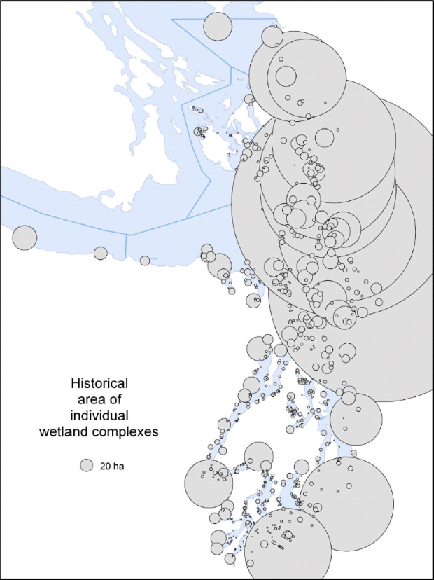
Figure 5. Historical area of individual wetland complexes (note: in all pie diagrams, wetland is proportional to the symbol area (reprinted with permission from Collins and Sheikh 2005)

Figure 6. Relative area of historical tidal wetland types in the estuaries of major rivers draining the Cascade Range and Olympic Mountains. EEM- estuarine emergent wetland; ESS- estuarine scrub-shrub wetland; RT- riverine-tidal wetland. (note: in all pie diagrams, wetland is proportional to the symbol area) (reprinted with permission from Collins and Sheikh 2005)
Uncertainties
Assessing the degree to which wetlands have changed over time is challenging. As with any analysis of historical trends, the frame of reference (baseline) can dictate the perception of change (e.g., Jackson et al. 2001), yet historical accounts are often less quantitative and thereby more subjective (Thom and Hallum 1990, Collins and Sheikh 2005). The use of historic maps from different sources is hindered by differences in terminology with respect to classifications of wetland hydrology, habitat or vegetation. Despite these challenges, the current efforts to recreate a quantitative picture of the extent and nature of historic wetlands have taken substantial measures to account for these difficulties (Thom and Hallum 1990, Collins and Sheikh 2005). The similarity of independent estimates derived from disparate sources strengthens confidence in them. Both Thom Hallum (1990) and Collins and Sheikh (2005) acknowledge that their estimates of historic wetland area may still be lower than their true extent given the limitations in the available data. The Puget Sound Nearshore Ecosystem Restoration Project (PSNERP) is currently conducting a closer investigation of intertidal wetlands using the database created by WDNR and UW. This effort is ongoing and will likely yield a more detailed analysis of wetland change in Puget Sound. While there has been much recent and ongoing efforts to restore wetlands in Puget Sound, the effectiveness and long-term sustainability has not been determined for the entire Puget Sound, though monitoring programs are used to document progress towards this end. The existing comparisons between current and historic wetlands do not currently separate restored wetlands from natural ones.
Summary
Tidal wetlands play an integral role in the hydrology, chemistry and nearshore ecosystem of Puget Sound and have experienced significant declines as a result of industrial uses, agricultural uses, and other types of human development. While much of the wetland loss and alteration occurred after 1900, dredging and channeling of large river deltas began as early as the 1850s. There have been several investigations into wetland change since pre-industrial times, each utilizing divergent or common data sources and deriving generally consistent estimates. The most recent and comprehensive assessment documents that the current area of tidal wetlands in Puget Sound is 17-19 % of historic levels and that most of the loss has occurred in the Whidbey Basin (Collins and Sheikh 2005). Ongoing investigations by PSNERP stand to shed more light on the extent and nature of current and historic wetland alterations in Puget Sound. Currently, efforts to restore estuarine and tidal wetlands hold promise for recovering lost ecosystem function.
Literature Cited
Bortleson, G. C., M. Chrzastowski, and A. K. Helgerson. 1980. Historical changes of shoreline and wetland at eleven major deltas in the Puget Sound region, Washington. U.S. Geological Survey, U. S. Dept. of, Justice, U.S. Bureau of Indian, Affairs, Reston, Va.
Boule, M. 1981. Tidal wetlands of the Puget Sound region, Washington. Wetlands 1:47-60.
Boule, M. E., N. Olmsted, and T. Miller. 1983. Inventory of wetland resources and evaluation of wetland management in western Washington. The Dept. of Ecology, Olympia, WA.
Collins, B. D., D. R. Montgomery, and A. J. Sheikh. 2003. Reconstructing the historical riverine landscape of the Puget Lowland Pages 79-128 in D. R. Montgomery, S. M. Bolton, D. B. Booth, and L. Wall, editors. Restoration of Puget Sound Rivers. University of Washington Press, Seattle, WA.
Collins, B. D., and A. J. Sheikh. 2005. Historical reconstruction, classification, and change analysis of Puget Sound tidal marshes. University of Washington (Seattle, WA) and the Nearshore Habitat Program, Washington State Dept. of Natural Resources, Olympia, WA.
Eissinger, A. M. 2007 Great Blue Herons in Puget Sound. . Seattle, WA.
Jackson, J. B. C., M. X. Kirby, W. H. Berger, K. A. Bjorndal, L. W. Botsford, B. J. Bourque, R. H. Bradbury, R. Cooke, J. Erlandson, J. A. Estes, T. P. Hughes, S. Kidwell, C. B. Lange, H. S. Lenihan, J. M. Pandolfi, C. H. Peterson, R. S. Steneck, M. J. Tegner, and R. R. Warner. 2001. Historical Overfishing and the Recent Collapse of Coastal Ecosystems. Science 293:629-637.
McMillan, R. O., D. A. Armstrong, and P. A. Dinnel. 1995. Comparison of intertidal habitat use and growth rates of two northern Puget Sound cohorts of 0+ age Dungeness crab, Cancer magister Estuaries 18:390-398.
Mitsch, W. J., and J. G. Gosselink. 2007. Wetlands. 4th edition. John Wiley & Sons, Inc., Hoboken, NJ.
Nesbit, D. M. 1885. Tide marshes of the United States. U.S. Dept. of Agriculture, Washington, D.C.
Simenstad, C. A., and J. R. Cordell. 2000. Ecological assessment criteria for restoring anadromous salmonid habitat in Pacific Northwest estuaries. Ecological Engineering 15:283-302.
Stick, K. C., and A. Lindquist. 2009. 2008 Washington State Herring Stock Status Report. Stock Status Report No. FPA 09-05, Olympia, WA.
Thom, R. M., and L. Hallum. 1990. Long-term changes in the areal extent of tidal marshes, eelgrass meadows and kelp forests of Puget Sound. Wetland Ecosystem Team, Fisheries Research Institute, School of Fisheries, University of Washington, Seattle, WA.


