

Ranking estuaries in the United States by size
Chesapeake Bay is widely seen as the largest estuary in the United States, and Puget Sound is often mentioned as the second-largest — or sometimes the largest estuary by volume, since Puget Sound is much deeper than the Chesapeake. Others high on some lists are San Francisco Bay and the Albemarle-Pamlica estuary in North Carolina.
Rarely mentioned is an estuary located in an out-of-the-way place, an estuary that turns out to be larger than any of the better-known U.S. waterways in more than one way.
An estuary, you might recall, is a “partially enclosed, coastal water body where freshwater from rivers and streams mixes with salt water from the ocean,” as defined by the Environmental Protection Agency.
In deciding which estuary gets first position, experts can measure the size in at least four ways: the area covered by water; the volume of water contained within the estuary; the length of its shoreline; or the size of an estuary’s watershed, which is the total land area drained by all the rivers and streams that flow into the estuary.
According to these measurements, Chesapeake Bay weighs in with a surface area of 4,480 square miles, according to the Chesapeake Bay Commission (PDF 493 kb). Puget Sound, as defined by oceanographers, is less than one fourth that size at 1,016 square miles (Encyclopedia of Puget Sound). Puget Sound is a little smaller than San Francisco Bay, which covers 1,600 square miles (EPA). [Editor’s note: There are inconsistencies in the way people define the geographic boundaries of Puget Sound, but for the purposes of this article, we defer to boundaries determined by oceanographers.] The Albemarle-Pamlico National Estuary Partnership boasts of more than 3,000 square miles of estuarine waters in North Carolina, although the boundaries of that waterway are not so easy to define.
The estuary that is rarely mentioned is Alaska’s Cook Inlet, which has a surface area of 7,930 square miles —close to double the size of Chesapeake Bay, as confirmed by bathymetric surveys of the Alaskan waterway (summary sheet along with full report).
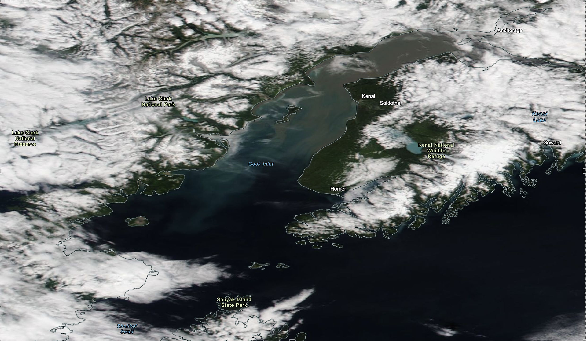
Mark Zimmermann, an expert in geographic information systems at NOAA’s Alaska Fisheries Science Center, stitched together extensive data from dozens of bathymetric surveys to come up with the size of Cook Inlet, as measured in various ways.
“I didn’t have any preconceived notions about the area or volume, but it is interesting that Cook Inlet isn’t really thought of as a big estuary,” Zimmerman said. “Areas like San Francisco Bay and Chesapeake Bay may be famous because they are near big cities. People really should know Cook Inlet, which happens to be near Anchorage, Alaska’s largest city.”
In fact, Cook Inlet, which is “partially enclosed” — as the EPA definition of estuary requires — may not be the largest estuary if one relaxes the definition to allow more open-water mixtures of freshwater. Norton Sound, which lies to the northwest of Cook Inlet, is an even bigger estuary by that relaxed definition used by some authorities. Alaska has other large coastal bodies of water as well. The “classic definition” of estuary used by EPA dates back to 1952 and is attributed to an oceanographer who studied Chesapeake Bay, according to Michael Fincham in Chesapeake Quarterly.
Considering the tides
The state of Alaska is surrounded by water on three sides. Like Puget Sound, many of the waterways were carved out by glaciers in ancient times. Being farther north than Puget Sound, the tides are even more extreme, with high tides as much as 33 feet above low tide. So when you are talking about the size of an estuary in Alaska, you must first ask a basic question: “Are you measuring the estuary during a high tide or a low tide?”
Cook Inlet, with a surface area of 7,930 square miles, was calculated at the average high tide. When the tide drops to an average low tide, the surface is reduced to 7,307 square miles, with 7.9 percent of the area becoming exposed shoreline. Since Chesapeake Bay does not fluctuate much, the 4,480-square-mile figure is a pretty good estimate during any tidal period. Puget Sound’s surface area of 1,016 square miles varies somewhat with the tides.
Although Puget Sound is deep — up to 938 feet — the claim that Puget Sound is the largest estuary by volume does not hold up against Cook Inlet because of the inlet’s vast area. Compared to Puget Sound’s volume of 40.3 cubic miles, Cook Inlet holds about 246.7 cubic miles of water, while Chesapeake Bay’s volume is less than 16 cubic miles.
Puget Sound is deeper, since Cook Inlet’s deepest spot is about 695 feet, and Chesapeake Bay’s deepest hole is 174 feet deep. For their average depth, Puget Sound is about 230 feet, Cook Inlet is 147 feet and Chesapeake Bay is 21 feet.
In terms of watershed (the land area that drains into the waterway), Chesapeake Bay comes out on top. Chesapeake Bay’s watershed spans some 64,000 square miles, with 39,000 square miles for Cook Inlet and 13,700 square miles for Puget Sound (PS Watershed Characterization).
[This 13,700 square miles for Puget Sound is based on the statutory definition of Puget Sound, which includes the Strait of Juan de Fuca and the San Juan Islands to the Canadian border. Experts we spoke to were not able to provide bathymetric measurements that fit this larger definition, so we used the traditional oceanographic definition of Puget Sound.]
There is an additional consideration when talking about the subject of “largest estuary.” Puget Sound is just the southern portion of a larger estuary called the Salish Sea. If the debate is expanded beyond the United States to all of North America, then we must talk about the entire Salish Sea, which extends into Canada. In fact, the Canadian portion of the waterway, often called Georgia Strait, is much larger than Puget Sound. The surface area of the Salish Sea is about 6,590 square miles, nearly as large as Cook Inlet’s 7,900 and bigger than Chesapeake Bay’s 4,480. (Separate figures published by the SeaDoc Society and Salish Sea Atlas are close estimates.)
Beyond the United States, the largest estuary in North America must include a waterway on the east coast of Canada called the St. Lawrence Estuary, which many experts call the largest estuary in the world. Its actual surface area is subject to debate because its open waters adjoin the much larger Gulf of St. Lawrence.