

Climate and ocean processes
This overview discusses the processes that control ocean and climate characteristics. Topics include atmospheric forcing, precipitation patterns, oscillation trends, coastal upwelling, and climate change.
 https://www.flickr.com/photos/mikeyskatie/5473869676")
The climate of Puget Sound is a product of the interaction between large-scale wind and weather patterns and the complex topography of the region. Seasonal changes in the movement of moisture-laden air that collides with the sudden barrier of the Olympic and Cascade mountains bring Puget Sound the record-breaking precipitation for which it is so famous. These circulation and topographic differences also lead to remarkable climate differences within Puget Sound itself, influencing the species and habitats that are found in the Sound.
Seasonality in Atmospheric Forcing

Beginning about mid-October, a semi-permanent lowpressure cell, commonly called the Aleutian Low, intensifies and migrates southeastward over the Aleutian Islands and Gulf of Alaska. Surface winds blow in a counterclockwise circulation around the Aleutian Low. Further south, winds blow in a clockwise circulation around a semi-permanent center of high pressure typically centered offshore of southern California. Together, these high- and low-pressure cells typically bring moist, mild, onshore flow into the Pacific Northwest from October through early spring. As the moisture-laden air encounters the Olympic or Cascade mountains, it rises and cools, and the cooling causes water vapor to condense into liquid cloud and rain drops. Because of the seasonal shifts in large-scale wind patterns, the PNW’s wet season typically begins in October, peaks in midwinter, and ends in the spring; about 75% of the region’s annual precipitation falls in the period October–March. During late spring, the Aleutian Low retreats to the northwest and becomes less intense, while the high-pressure cell to the south expands northward and intensifies. The result is a strong reduction, from late spring through summer, of landfalling storms for the Pacific Northwest.
Precipitation Patterns and Localized Variability
The west (windward) slopes of the Cascade and Olympic mountains receive enormous quantities of rain and snow, exceeding 200 inches (5 meters) of water equivalent per year at some locations on the Olympic Peninsula. At Paradise Ranger station on Mount Rainier, the average spring sees an end-of-season snow depth of 4.1 meters (~170 inches). The Cascades are often among the snowiest places on Earth: in 1956 the snow at Paradise piled to a depth of nearly 9.1 meters (30 feet) during a year in which that location’s annual snowfall was nearly 28.5 meters (94 feet); the Mount Baker Ski Area, located in the North Cascades near the U.S./Canada border, set a new world record for the highest annual snowfall ever recorded (October–September) in 1998–99 with a total of 29 meters (96 feet) (Bell et al. 2000).

Although the west side of the Cascades is generally a very wet region, it contains several areas that receive significantly less precipitation than the west-side average. Washington’s Puget Lowlands, the northeast extreme of the Olympic Peninsula, and the San Juan Island arch- ipelago are relatively dry areas that lie in “rain shadows.” Rain shadows in these areas are caused by the Olympic Mountains located to the west and southwest that shield them from the direct impact of storms that follow the wet season’s prevailing storm track.
The Cascade Mountains also bear strongly on seasonal variations in the region’s climate. West of the Cascades, the low-lying valleys have a maritime climate with typically abundant winter rains, infrequent snow, dry summers, and mild temperatures year-round (usually above freezing in winter, so that snow seldom remains for more than a few days). East of the Cascade crest, the region’s climate is much more continental, with rainfall and cloudiness less common and sunshine and dry conditions more common year-round. On a finer scale, gaps and low-elevation passes in specific locations provide connections between the east-west climate differences, affecting habitat-forming processes and the spatial distribution of the biota of the west slopes of the Cascade mountain range.
The El Nino-Southern Oscillation (ENSO) and the Pacific Decadal Oscillation (PDO)
The year-to-year and decade-to-decade changes in the strength and location of the Aleutian Low have been a prominent feature of Pacific climate variation in the last century. Climate records indicate that one of the most prominent features of Pacific climate variation are expressed through annual and decadal changes in the strength and location of the Aleutian Low pressure pattern. This is of special importance for Puget Sound because an intense Aleutian Low brings relatively warm and dry winters to the region, while a weak Aleutian Low favors a cooler and wetter winter. Variability in the Aleutian Low comes from a variety of sources, but two important influences on the Aleutian Low are the large- scale variations in sea-surface temperatures known as the El Niño-Southern Oscillation (ENSO) and the Pacific Decadal Oscillation (PDO).
ENSO is a natural part of Earth’s climate that spontane- ously arises from interactions between tropical trade winds and ocean-surface temperatures and currents near the equator in the Pacific. Warm extremes of the ENSO cycle, commonly called El Niño, favor an especially intense Aleutian Low that is associated with the displacement of the storm track in the eastern North Pacific. As the displacement moves the track southerly towards California, the conditions favor a warm and mild Puget Sound winter. Cold extremes of the ENSO cycle, commonly called La Niña, favor the opposite. Individual ENSO events (either El Niño or La Niña) typically occur over the course of a single year, and over the past century one year in four (on average) has been an El Niño extreme, and one year in four has been a La Niña extreme.
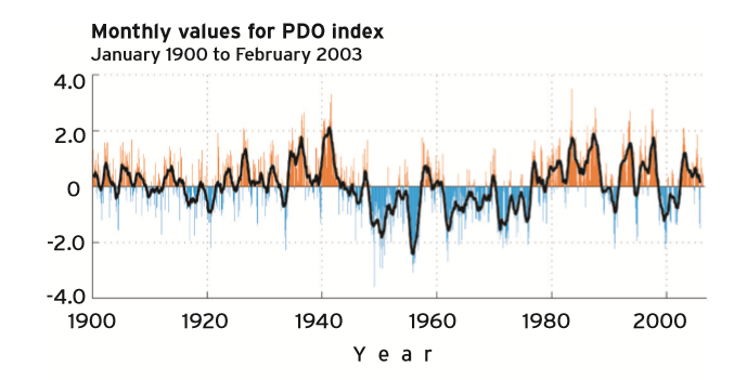
The Pacific Decadal Oscillation plays out over a longer time-scale, with a typical lifetime of 20 to 30 years for the extremes. Warm eras of the PDO prevailed during 1925– 46 and 1977–98, while cold eras prevailed during 1900–24 and 1947–76. Warm eras of the PDO are associated with a with different climate regimes—including changes in zooplankton, benthic algae, meso-crustaceans, rocky-reef fishes, and apex predators. The effects of regime shifts vary geographically-–Pacific salmon from Alaska increased in abundance in response to the 1976 regime shift while populations from the Pacific Northwest declined.
Potential changes in global climate patterns are likely to have important consequences to Puget Sound ecosystem processes. Changes in precipitation, temperature, and the frequency of intense Aleutian Low systems will alter freshwater input, nutrient cycling, and stratification with ramifications throughout the food web. The Climate Impacts Group at the University of Washington has published two important reports (Snover et al. 2005; Mote et al. 2005) that document a number of potential impacts that climate change may have on the Puget Sound ecosystem. [Editor's note: For the most recent information about current and projected climate impacts in the region, view the 2015 report State of Knowledge: Climate Change in Puget Sound. ]
Coastal Upwelling
An ecologically important consequence of the seasonal changes in PNW coastal winds is the relationship between wind patterns, currents, and the input of nutrient-rich waters, a phenomenon known as “coastal upwelling.” The switch from northward, winter wind patterns to more frequent southward winds in the summer months drives ocean surface currents offshore which are replaced by cool, nutrient-rich waters from greater depths. Upwelling is important for marine ecosystems because it helps supply nutrients to the upper ocean where sunlight is generally abundant during the summer. Phytoplankton require a combination of sunlight and nutrients to produce food through photosynthesis, and high phytoplankton production helps fuel high productivity throughout the marine food web.

References
Mote, P.W., A.F. Hamlet, M.P. Clark, and D.P. Lettenmaier. 2005. Declining mountain snowpack in western North America. Bullet in of the American Meteorological Society 86:39
Snover, A.K., P. W. Mote, L. Whitely Binder, A. F. Hamlet, and N. J. Mantua. 2005. Uncertain future: climate change and its effects on Puget Sound. Climate Impacts Group, Center for Science in the Earth System, Joint Institute for the Study of the Atmosphere and Oceans, University of Washington. 35 p.
 region")


