Watersheds
Find articles, maps, and other content tagged by any of the 21 watershed sub-basins in the Puget Sound area. The geospatial boundaries below represent the 4th level (8-digit) hydrologic unit boundaries of the Watershed Boundary Dataset (WBD) layer for Washington. Data source: The U.S. Department of Agriculture, Natural Resources Conservation Service.
RELATED ARTICLES
Puget Sound watershed hydrologic units
There are many ways of defining the boundaries of the Puget Sound watershed. Hydrologic unit codes (HUCs) are nationally standardized divisions that are often used by conservation agencies and national organizations.

Water Resource Inventory Areas in Puget Sound
The Washington State Department of Ecology and other state natural resources agencies have divided the Washington into 62 "Water Resource Inventory Areas" or "WRIAs" to delineate the state's major watersheds.
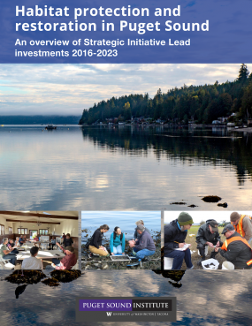
Habitat protection and restoration in Puget Sound: An overview of Strategic Initiative Lead investments 2016-2023
Between 2016 and 2021, $21 million provided by the Environmental Protection Agency (EPA) funded 100 different projects to protect, restore, and study critical habitats in Puget Sound. This publication presents an overview of many of the key accomplishments and lessons learned from these efforts. It is a catalog of some of the ‘big ideas’ presented by the scientists and conservationists involved, and it is meant to inform and guide future Puget Sound recovery efforts. This overview is based on the full synthesis report, “Synthesis of Habitat Strategic Initiative Lead 1.0 2016-2023 Investments for Puget Sound Recovery," published by the Puget Sound Institute.
")
Study raises questions about using ‘woody debris’ to restore streams
A new report says further study may reveal why experts cannot find expected benefits to salmon populations, despite widespread use of wood in stream restorations.

The retreating glaciers of Puget Sound
Puget Sound's glaciers are melting rapidly due to climate change. The North Cascades mountains have lost about 56% of their glacial ice while estimates show that glaciers in the Olympics could be gone within the next 50 years. Scientists say salmon and other species could be hard hit as the region loses its “giant storage tank” of ice.
")
Puget Sound National Estuary Program Synthesis of Integrated Floodplain Management in Selected Puget Sound River Deltas
A 2021 synthesis report from the University of Washington Puget Sound Institute synthesizes leading integrated floodplain management approaches to support the EPA-funded Floodplains and Estuaries Implementation Strategy.
")
Salish Sea survey: Geographic literacy enhancing natural resource management
An article published in the journal Society & Natural Resources in 2021 describes the results of a geographic literacy survey which shows residents of Washington and British Columbia are largely unfamiliar with the name Salish Sea. The authors discuss the implications of their findings for ecosystem recovery of the region.