Keywords: Climate change, Human quality of life, Terrestrial habitat, Salish Sea Currents magazine

Historically, the eastern part of the state has seen the largest impacts from fires, but climate change is now increasing the risk west of the Cascades. That could have big implications for many rural communities throughout Western Washington, including those in the Puget Sound region.


The summer of 2015 brought hot, dry winds blowing into Western Washington from the east. Ominous breezes parched the forests, promoted wildfires and foreshadowed a future of increased fire danger on the “wet side” of the Cascade Mountains.

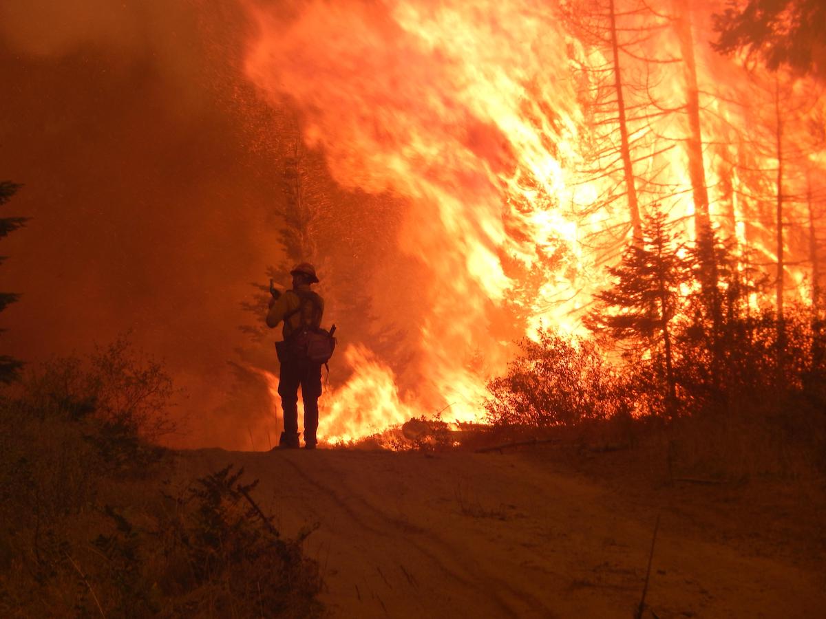
On Aug. 10 of that year, a lightning strike on Mount Ross in North Cascades National Park ignited a slow-moving fire on a precipitous slope. The blaze smoldered along for more than a week before it blew up on Aug. 19, when strong winds pushed the flames toward the small town of Newhalem. The fire grew from about 100 acres to about 3,200 acres in a single day.

Researchers who study the risk of wildfire say a warming climate in Western Washington could bring an increasing number of fires to the doorsteps of more than a million homes scattered through the woods or clustered in small communities throughout Western Washington.

Newhalem is a company town owned by Seattle City Light. Employees who live there operate the extensive Skagit River Hydroelectric Project, which provides power to the Seattle region. Cynthia Stahlecker, operations secretary, recalled the intense flames, smoke and heat as the fire approached.

“You could see the fire coming over the hill,” she said, “and then it jumped the river and circled the town. The smoke was so thick that I couldn’t see out the back door. The sound was like a great big jet engine taking off. I have never experienced anything like that, nor do I ever want to again.”

That night, as firefighters battled the smoky blaze at the edge of town, emergency officials organized an evacuation of Newhalem residents as well as those living in nearby Diablo. The North Cascades Highway was blocked to the west, so a convoy of vehicles escaped over the mountains into Eastern Washington.

The convoy, originally bound for Winthrop, was diverted to Wenatchee to avoid an extreme forest fire that has been called the Okanogan Complex Fire. During August of 2015 — the hottest year on record — Eastern Washington suffered through a series of forest fires that burned a record 1.1 million acres, killing three firefighters and destroying 123 homes.

Historically, the evacuation of Newhalem and Diablo stands as one of the few fire-driven escapes from populated areas west of the mountains. But researchers who study the risk of wildfire say a warming climate in Western Washington could bring an increasing number of fires to the doorsteps of more than a million homes scattered through the woods or clustered in small communities throughout Western Washington.

Maritime climate changing

Western Washington — between the Pacific Ocean and the Cascade Mountains — is known for its cool, moist breezes blowing in from the sea. For the past 300 years, wildfires have been rare and relatively small, thanks to moist vegetation and infrequent lightning storms. Early loggers talked about their discovery of “asbestos forests,” which would provide a vast supply of quality lumber to a growing nation.

The Hoh Rainforest on the Olympic Peninsula in western Washington. Photo: Tjflex2 (CC BY-NC-ND 2.0)

The Hoh Rainforest on the Olympic Peninsula in Western Washington. Photo: Tjflex2 (CC BY-NC-ND 2.0)

When it comes to fire behavior, Eastern and Western Washington are recognized as “different worlds with very little overlap,” according to Dave Peterson, who studies fire science and climate change at the University of Washington’s School of Environmental and Forest Sciences.

Under natural conditions, fires on the east side tend to be less intense but more frequent. Dry conditions produce less vegetation to fuel the flames. At the same time, lightning strikes occur more often in Eastern Washington, providing the sparks for recurrent fires. This natural cycle can be disrupted when humans put out the fires, allowing fuels to build up. The ultimate consequence is larger and more intense fires.

Meanwhile, the wetter conditions of Western Washington encourage dense vegetation to grow quickly. Potential fuels accumulate over time, not only from the prosperous growth of living trees and underbrush but also from fallen logs, dead brush and decaying “duff” that builds up on the forest floor. As fuels pile up, fire waits for the right conditions — specifically a long dry spell, a source of ignition and winds to fan the flames.

If humans don’t ignite a fire, a century or more may come and go before all the right conditions come together in Western Washington for a widespread fire to take off and burn with great intensely.

Understanding the differences between Eastern and Western Washington has led some fire researchers to propose a separate strategy for combatting fire hazards on the west side of the mountains. Actively thinning forests and reducing fuel loads may work in Eastern Washington, where such efforts are currently underway. But in Western Washington, vegetation generally grows back too fast for thinning to be an effective treatment, researchers say. Besides, thinning the dense plants that fuel fierce west-side fires could eliminate a variety of species that depend on this special habitat.

Ancient fires of Western Washington

Over the past 1,000 years, three major burn periods in Western Washington have been identified by scientists, who estimate fire dates by studying the age of trees growing on the landscape and by examining the “burn scars” left among tree rings, as seen in the cross-section of a log.

One large fire or a series of smaller fires swept across Western Washington around 1308, followed by another great burning period from 1448 to 1538, when several fires occurred. The latest period of conflagration involved a pair of major fires, one about 1668 and the other about 1701.

Because each of these intense “stand-replacing” fires consumed evidence from the ones before, the best documentation comes from the 1701 fire, which burned an estimated 3 million to 10 million acres across Western Washington, according to a technical report developed for the U.S. Forest Service. For comparison, 10 million acres is roughly equivalent to the entire Puget Sound watershed or about 10 times the size of Olympic National Park. Many of the old-growth trees that supplied lumber for a burgeoning industry in the 1800s got their start soon after the 1701 fire wiped out much of the vegetation that existed at the time.

For the past 300 years, fires in Western Washington have been small compared to the great fires of ancient times. They usually occurred during drought years, and the larger fires were generally accompanied by strong winds from the east. Such was the case with the 1902 Yacolt Burn, the largest fire in Washington state history up until 2014. The fire, near the Columbia River, scorched 239,000 acres of forestland in Southwest Washington and nearly that much across the river in Oregon.

Since 1985, Western Washington has seen 12 fires of more than 1,000 acres, which have burned about 50,000 acres in total. That includes the 6,632-acre Goodell Creek fire, which led to the evacuation of Newhalem and Diablo in 2015, as well as the 51,000-acre Norse Peak Fire in 2017 near Mount Rainier, a fire that burned equal areas (about 25,000 acres) in both Eastern and Western Washington.

Compared to Western Washington’s 12 fires that scorched 50,000 acres since 1985, Eastern Washington has experienced 507 fires of over 1,000 acres each, burning just over  6 million acres — including some areas affected by fire more than once.

The Goodell Creek Fire burned 6,632 acres near Newhalem, Washington in 2015. Photo: Seattle City Light

The Goodell Creek Fire burned 6,632 acres near Newhalem, Washington, in 2015. Photo: Seattle City Light

While nobody expects climate change to turn Western Washington into Eastern Washington, climate experts say the wetter side of the state may be transitioning out of a period of relatively small and low-intensity fires.

Perhaps aside from climate change yet adding to the concerns, recent weather conditions suggest that Western Washington may be moving out of a fairly long period of sustained dampness that began in the 1930s, according to Peterson.

 “We do know that droughts were a lot more common — and lasted longer —prior to 1900,” Peterson said. “There is plenty of fuel out there. If we get back to a more normal drought cycle, we could expect to see those fuels dry out more often.”

Such conditions on top of climate change could lead to an increasing risk of a devastating wildfire across Western Washington, as well as an increasing number of smaller fires.

Measuring risk

Predicting the future of wildfire in Western Washington is a real challenge, researchers say, because there are so few fires to be studied. A similar challenge confronts emergency managers who try to convince residents who live in wooded areas that they need to take steps to protect their families and property from wildfire.

“The general public seems to think that fire is not something they need to worry about,” said Kevin Zerbe, state mitigation strategist for the Washington Emergency Management Division. “It’s hard to communicate the level of risk, because there are few historical events we can point to.”

Among the 11 western states, Washington has the greatest amount of residential property in wooded areas, known as the wildland-urban interface, according to the state’s “Enhanced Hazard Mitigation Plan.”

It is not hard to find communities surrounded by nearby forests in Western Washington. Some look much like the town of Paradise, Calif., where in late 2018 a raging wildfire killed 86 people, destroyed 18,000 buildings and burned 150,000 acres. Most of Paradise became piles of ash that previously had been homes and personal belongings.

The blaze, named the Camp Fire, started from an arcing power line. Some experts say climate change contributed to the tinder-dry conditions that led to the most destructive fire in California history.

The remains of homes that burned during the 2018 Camp Fire in Paradise, California. Photo: CalOES

The remains of homes that burned during the 2018 Camp Fire in Paradise, California. Photo: CalOES (CC BY-NC 2.0)

Northern California is different from Western Washington in many ways, Zerbe said, “but I don’t think it is entirely out of the question to have a fire like that in Western Washington. From a purely exposure standpoint, I think it is possible.”

Although well known for its rains, Western Washington has its moments when extreme drought and high heat come together to dry out the forests. Large amounts of fuel already exist. All that is needed is wind and something to spark a blaze — either a human source or a bolt of lightning.

Brian Potter, a research meteorologist for the U.S. Forest Service, says strong east winds associated with extreme fire conditions are often generated from a thermal trough, which develops along the coast beginning in Northern California and gradually extends into Western Washington. This low-pressure region brings strong and shifting winds up and over the Cascade Mountains, compressing the air in the Puget Sound lowlands and causing even hotter and dryer conditions. The trough is often associated with few clouds and no precipitation.

During fire season, California is generally known for having stronger and more sustained downslope winds than Western Washington. In Southern California, the winds are called Santa Ana winds, while in Northern California they are known as Diablo winds. In recent years, months of summer drought in California followed by extreme dry winds have led to unstoppable fires that have torched entire communities.

Satellite image of the 2018 Camp Fire in Butte County,California. Photo: NASA

Strong winds contributed to the Camp Fire in Butte County, California which burned nearly 240 square miles in 2018. Photo: Joshua Stevens/NASA.

Because east winds play a powerful role in Western Washington wildfires, emergency managers would like to know how climate change could affect the frequency and force of the winds. Some climatologists speculate that warmer, more uniform temperatures might even weaken the winds to some degree. A new climate study, just getting underway, could help determine how future winds might alter the threat of a catastrophic wildfire.

The Great Forks Fire

In Washington state, strong east winds during the summer of 1951 were blamed for an inferno on the Olympic Peninsula that raced through 18 miles of forestland in a single day and led to the evacuation of hundreds of residents from the town of Forks.

 “The fire made everyday heroes out of men and women who grabbed hoses and watered-down houses and businesses,” wrote Mavis Amundson in her 2003 book “The Great Forks Fire.” The fire itself captured her historical interest, Amundson said in a recent interview, but the real story came from hearing survivors tell of their determination to save the town.

The initial fire was ignited on Aug. 6 by a steam-powered logging train traveling through Olympic National Forest. It took dozens of firefighters, some with bulldozers, to bring the fire under control after it had burned 1,600 acres. Fire crews then spent weeks mopping up and putting out the hot spots before no signs of smoke remained. But the fire was not done.

The ominous east winds returned, stronger than ever, on Sept. 19. Somewhere in the burned debris a smoldering ember reignited the blaze, which moved so fast that fire crews had no defense.

 “It blew over our heads and jumped ahead of us,” said Lew Evans, an assistant district ranger for the Forest Service, as quoted by Amundson, who went on to describe the fire that headed directly for Forks with flames hundreds of feet high. Although most people were evacuated, some remained in town where they scrambled to extinguish fires caused by falling embers.

 “Loggers, sawmill workers, firefighters, shopkeepers, retirees and others helped save their town from the advancing fire,” Amundson wrote. “With little more than bulldozers, shovels, garden hoses, some outdated firefighting equipment and a pitiful water supply, these heroic townspeople helped hold back the forces of nature.”

And yet, despite their efforts, the townsfolk came to realize that they could not overcome the searing forces of the main fire as it neared the edge of town. Forks appeared to be doomed, Amundson wrote.

“Then, out of the west, came a fresh wind that blew in off the Pacific Ocean, cool and moist, and just strong enough to stop the fire’s advance. The town was spared.”

Remarkably, nobody was killed or seriously injured in the Great Forks Fire, which destroyed about two-dozen homes and burned through 33,000 acres of valuable timberland.

Effects of a warming climate

On both sides of the Cascade Mountains, extremely dry weather during 2015 produced wildfires that turned out to be extraordinarily intensive and widespread. Some climate researchers have declared the 2015 fire season in Washington to be a likely “harbinger” of future conditions as the climate grows warmer.

In Eastern Washington, 42 fires each larger than 1,000 acres burned some 1.1 million acres during 2015. Both the number of fires and the amount of area burned in 2015 broke the record for modern times. That eclipsed the previous record of 415,000 acres burned the year before, when the 276,000-acre Carlton Complex Fire dominated the news.

The worst fire year

The 2015 fires in Eastern Washington included the 219,000-acre North Star fire on the border of Okanogan and Ferry counties plus three fires to the west, sometimes lumped together as the Okanogan Complex: Tunk Block, 180,000 acres; Lime Belt, 137,000 acres; and Twisp River, 11,000 acres.

Meanwhile, in Western Washington, Olympic National Park officials kept watch over a rare fire in the Queets Rainforest, a wilderness area where the fire was allowed to burn throughout the summer. After covering 2,800 acres, the fire went out during November rains.

Aerial image of Washington on August 22, 2015 showing the Puget Sound region covered in smoke from wildfires in Eastern Washington. Photo: NASA

In 2015, the Puget Sound region was covered in smoke from wildfires in Eastern Washington. Photo: NASA

It turns out that the extreme temperatures recorded in 2015 — about 1.7 degrees higher than normal — are within the range of average temperatures projected for midway through this century, according to a research report titled “The 2015 drought in Washington State: a harbinger of things to come?”

“Our results show that the drought conditions of 2015 occurred despite near-normal winter precipitation,” according to the study led by Miriam Marlier, an environmental scientist at the University of California, Los Angeles. “Given the general similarity between 2015 and projected future conditions, this suggests a transition from precipitation to temperature control in future droughts.”

Fire danger, as measured by fuel dryness, is expected to increase over time as climate change contributes to more frequent drought conditions.

In the Northwest, average annual temperatures have increased by about 1.6 degrees Fahrenheit since the 1920s — with most of that coming in the past 30 years. Over the next 30 years or so, average temperatures are projected to go up another 2.9 to 5.4 degrees, provided that greenhouse gas emissions are brought down. At the upper extreme with higher emissions, average temperatures could rise by more than 7 degrees, according to some models.

Most climate models suggest that the largest temperature increases will come in the summer months, when extreme temperatures — such as 95 degrees — become ever more common. Future summers also are projected to become drier.

Hot summers are expected to trigger both a larger number of fires and an increasing extent of areas burned. Snows that accumulate during winter will melt away earlier in the year, not only because of higher temperatures but also because more precipitation will fall as rain.

The so-called fire season — when forest fuels are most flammable — can be expected to begin earlier in the spring and extend later into the fall.

While it is easy to think of Western Washington as a continuous forest apart from Eastern Washington, scientists are quick to point out that the west side is actually made up of a variety of biotic communities where different types of trees dominate. Topography, elevation and rainfall are key determiners in the type and growth rate of trees and associated undergrowth.

In particular, the Puget Sound lowlands are characterized by more frequent and less severe fires than the slopes of the Cascade Mountains to the east or the Olympic Peninsula to the west.

Fire behavior is affected by multiple conditions, the sum of which determine whether a fire creeps along the ground, burns upward among  “ladder fuels” to reach higher branches, or grows into an inferno, with flames racing through the crowns of trees and burning everything on the ground below.

Western Washington strategies

Across much of Washington state, logging and forestland management have altered the condition of the forests — including the type and diversity of tree species. In the face of climate change, many forest ecologists and silviculturists advocate managing forests for future conditions.

“I think we’re getting the message out that we need to thin our dry forests in Eastern Washington,” said Josh Halofsky, a forest researcher for the Washington Department of Natural Resources. But in Western Washington, he argues, the story plays out much differently.

Fuel removal is simply not practical where vegetation grows so rapidly that frequent treatment would be needed across a vast area. Furthermore, such treatments would disrupt the ecosystem for west-side species dependent on the natural vegetation.

In an article published in the journal Ecosphere, Halofsky and five other researchers described a different management approach for a region affected by fewer fires with greater destructive potential.

Strategy 1.

Attack fires while small in areas close to man-made structures or to protect commercial timber values, municipal watersheds or critical habitat, such as an old-growth forests containing endangered species. Elsewhere, consider whether managed wildfire might have ecological benefits.

In some areas of Western Washington, lightning-caused fires have been allowed to burn. The idea is that fire, which is a natural part of ecological history, can alter habitat in positive ways and reduce the risks of more intense fires in the future.

Such fires may have some ecological benefits, the researchers said, but they are unlikely to have much effect on fuel loading, and they run the risk of turning into a much larger fire if weather conditions change. So all factors should be considered.

Strategy 2.

Pending the inevitable large fires, manage for appropriate species diversity. Ideas include promoting habitat connectivity, controlling invasive species and promoting genetic diversity to help maintain forest health in the face of climate change.

“For example, retaining an abundance of broadleaf species in stands and across the landscape may provide several important ecosystem benefits,” the article states. “Deciduous hardwood species can reduce the flammability of forests and landscapes dominated by conifers, add to resilience by sprouting in response to disturbance, use less water than evergreen conifers resulting in more streamflow, and enrich forest habitat for many biota.

“Depending on management objectives and rotation length, diversifying the landscape can also sustain the economic viability of timber production in an uncertain future,” the article continues, adding that older, larger trees are more likely to survive a fire and can provide seeds for the next generation.

Strategy 3.

After a major fire, land managers should use the opportunity to grow a forest more suitable to changing climate conditions while learning from the process. For actively managed forests, having a post-fire plan in place will help to ensure an effective response.

Rather than harvesting trees that survive after a fire, allowing surviving patches of trees to grow creates a forest mosaic and facilitates ecosystem recovery.

Depending on management objectives, one could allow some stands to regenerate naturally. Otherwise, one could replant with climate change in mind, perhaps with less density and with a variety of species tolerant to lower moisture conditions, especially on dryer south-facing slopes.

The rare, devastating fires of Western Washington can strike without warning and create conditions for a new forest. Where fire takes place, the adaptation to climate change may come suddenly.

“Careful planning now,” the article concludes, “will allow organizations to articulate a range of future possible responses …, setting reasonable expectations for what management can and cannot do to foster resilience.”

Think Firewise sign

In a forest fire, defensible space might save your house

The Goodell Creek Fire, which led to the evacuation of Newhalem and Diablo in 2015, could have been far more damaging to homes and property had it not been for some preparations before the fire, along with a little luck.

Living in a wooded area always involves a risk that one’s home might be destroyed by wildfire, experts say. The actual level of risk is not easy to determine, but property owners can take actions to shift the odds in their favor.

Up to 80 percent of all houses lost to wildfire might have been saved if the owners had taken some simple steps, according to information from the Washington Department of Natural Resources. Such actions include creating so-called “defensible space” around buildings — a tactic used by Newhalem Fire Chief Cody Watson before and during the Goodell Creek Fire.

The fire began on Aug. 10, when lightning struck just inside North Cascades National Park. It grew slowly until Aug. 19, when high winds pushed the flames across the Skagit River just east of Newhalem. From there, residents could see the blaze approaching the town from both the north and south as smoke enveloped the area.

Watson, named as fire chief for the community less than a year before, scrambled to direct Seattle City Light employees, who were running sprinklers to dampen lawns in the company town and scurrying to put out spot fires caused by a rain of embers.

“The fire went from small to huge very quickly,” Watson recalled. “I knew it was bad when I could hear the embers coming down.’

As the fire advanced toward Diablo, employees evacuated the power plant, which is part of the Skagit River Hydroelectric Project. Diablo residents were evacuated to the east, joined by staff from North Cascades Institute’s Environmental Learning Center and Ross Lake Resort. Some Newhalem residents left with them and some remained.

Firefighters focused on protecting the power facilities along with dozens of houses and administrative buildings in Newhalem.

Fortunately, a few months before the fire, the community had joined the Firewise Communities program, which is all about creating defensible space. Workers cleared out flammable plants and materials from around buildings well before the fire and then removed remaining materials as the flames approached.

The fire skirted Newhalem and advanced toward Diablo. With about a mile to go, the winds suddenly shifted and the air cooled. Heavy rains soon followed to put the fire out. No structures were lost, and no serious injuries were reported.

“We were fortunate on many levels,” Watson said. “I’m grateful that, as close as the fire came, we were able to make it through.”

The Department of Natural Resources recommends that all residents living in forested areas take step to protect their homes. The agency lists 12 steps (pdf) for creating a 100-foot perimeter of defensible space around a home or other structure. Ideas include clearing leaves and branches from the ground, removing other flammable materials and strategically pruning nearby trees.

Fire-resistant plants can be used in landscaping around a house to avoid adding fuel to a fire.

Protecting the house itself includes keeping roof valleys and rain gutters free of pine needles, leaves and flammable debris, as well as adding screens to vents to keep embers from entering the attic. Double-pane or triple-pane windows are better than single-pane, and decks of fireproof material are better than regular wood.

Success in avoiding destructive house fires can be enhanced when neighbors work together to form Firewise communities, administered through the National Fire Protection Association, according to DNR. So far, 138 communities in Washington state are listed as Firewise USA participants.

To organize a Firewise USA organization or obtain information about fire protection, contact the local conservation district in the county where the house is located. Another option is to reach out to DNR staffers, including Ashley Blazina, Firewise coordinator for Western Washington, (360) 902-1300, ashley.blazina@dnr.wa.gov.

Defensible space can be created around existing homes without much expense, experts say, but it may not be enough during the rarest of fires that come with extraordinary heat and extreme winds, such as the Camp Fire in Paradise, Calif. Fire investigators say houses with defensible space probably did better in that fire than those without, yet many houses burned despite the preparation.

What appeared to help the most during the Camp Fire was the structure of the houses themselves. In 2008, California updated its state building code for fire-prone regions. New houses must be built with fire-resistant roofs, siding and other special safeguards. Of the homes built in Paradise after 2008, 51 percent survived the fire undamaged, compared to a survival rate of only 18 percent for houses built before the new code, according to an analysis conducted by McClatchy newspapers.

When building a new house in the woods, owners may wish to take a clue from California’s building codes, experts say. Meanwhile, everyone living in vulnerable areas can benefit by creating — and maintaining — defensible space.

Video: Your Home and Wildfire. Choices that can make a difference. National Fire Protection Association.


About the author: Christopher Dunagan is a senior writer at the Puget Sound Institute.

Series:
Implementation Strategies

Sponsored by:

United States Environmental Protection Agency logo

Creative Commons License
Story text available under a Creative Commons Attribution-NonCommercial-NoDerivs license: CC BY-NC-ND 4.0.