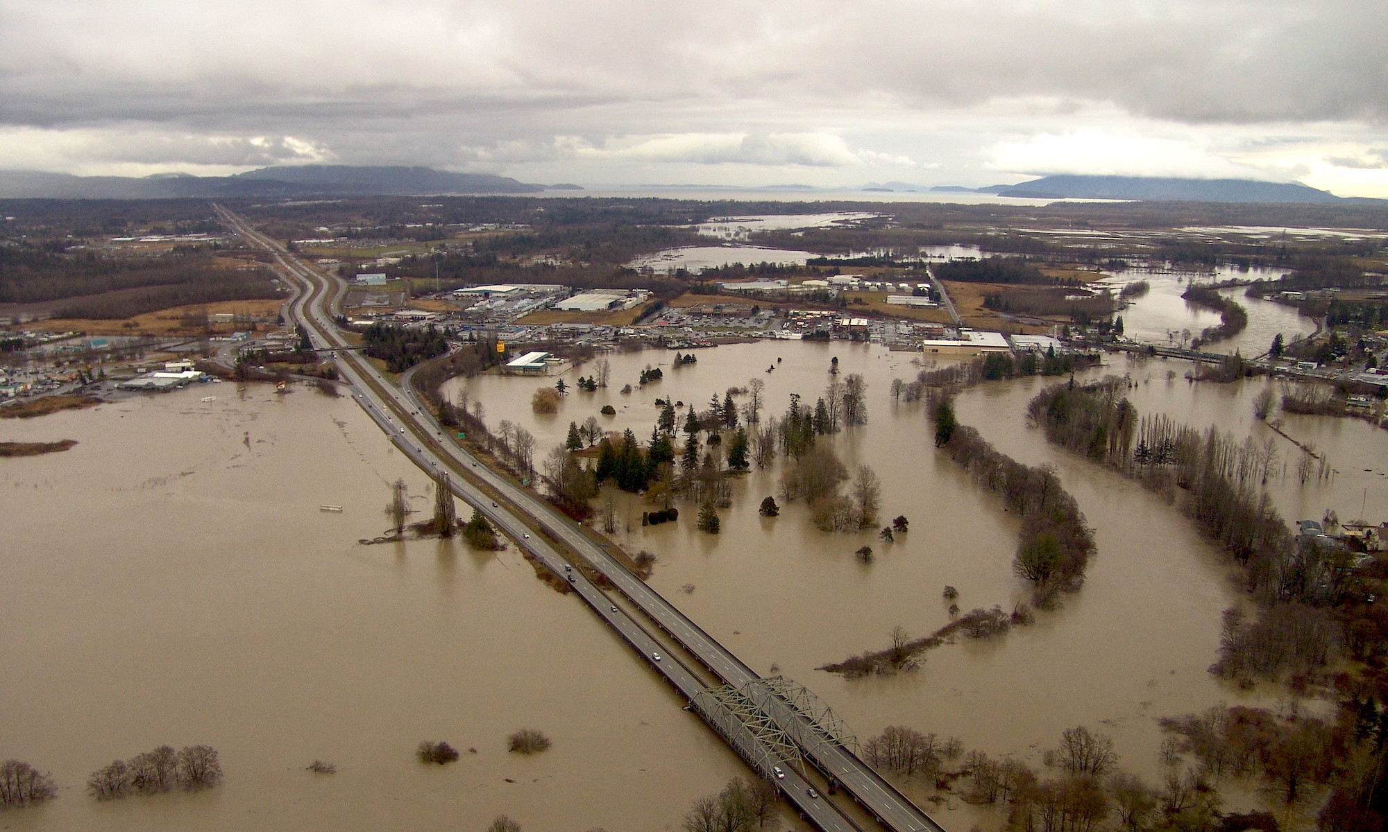
On the morning of December 27, 2022, a mix of torrential rains, exceptionally high tides, and heavy snow melt caused the Duwamish River to flood in south Seattle. Water overtopped the river’s banks and flowed down the streets of South Park. One resident told KOMO News that three feet of water had poured into his home in “a matter of minutes.” By the time the floodwaters had receded, dozens of homes and businesses had been affected, resulting in millions of dollars in damage.
In the aftermath, the Seattle city government noted that, while the metropolitan area as a whole was likely to see significant effects of sea level rise, the low-lying Duwamish Valley “is among the most vulnerable areas in Seattle to these impacts.” Several months later, Senator Patty Murray toured South Park as part of her effort to get several million dollars of federal funding for flood mitigation work. “Everyone, in South Park and across Seattle, knows that rising sea levels and extreme storms are becoming the new normal and so is flooding,” she said in a statement.
The floods of last December were neither restricted to the Seattle area nor, necessarily, to December. All throughout Puget Sound people are dealing with the consequences of rising waters, whether due to high river flows or high marine water levels. Both vulnerabilities were the focus of several climate change-related grants from the Habitat Strategic Initiative Lead (HSIL). The awards, distributed on behalf of the Environmental Protection Agency, focused on quantifying vulnerability, increasing manager capacities, providing technical guidance to municipalities and other stakeholder groups, and raising public awareness both for and about climate-related issues throughout the Puget Sound region.
Puget Sound recovery strategic initiatives
This article was commissioned by the Habitat Strategic Initiative Lead (HSIL), a cross-agency team co-led by the Washington Departments of Fish and Wildlife and Natural Resources, as part of a grant to the Puget Sound Institute to synthesize and communicate on 100 grant awards made by the HSIL between 2016-2020 with EPA Puget Sound Geographic Program funds.
About HSIL
The 2012-2013 Action Agenda for Puget Sound developed by the Puget Sound Partnership established three initiatives to tackle multiple issues critical to Puget Sound recovery:
- habitat protection and restoration
- shellfish bed protection and recovery
- stormwater pollution prevention.
To manage this effort, agency and institutional partners assembled into three Strategic Initiative Lead (SIL) teams, charged with bringing people and ideas together to improve the water, habitat, and communities. Read more about the Puget Sound Recovery Program.
The role of HSIL is to implement plans that improve the health of the rivers, forests, shorelines, and estuaries that make up Puget Sound.
Flood management and sea-level rise projects funded by HSIL:
For some HSIL award recipients, simply explaining how rivers in the Pacific Northwest function was a critical component. A river can wind without being allowed to roam as it used to. Removing plants and building dikes and other structures creates, in effect, a kind of riparian raceway. Planting vegetation and placing large woody debris—anchoring downed trees in the riverbanks, in essence—can slow a river down, make it wend a little more. This in turn lessens the flooding risk to surrounding communities, in addition to providing habitat for fish and other organisms.

Engineered log jams like this one installed in the South Fork Nooksack River can reduce the risk of flooding by slowing down the flow of the river. Photo: Lance Cheung/USDA NRCS
“The basic motivation is that there’s a lot of dimension to floodplain management and preparedness,” says Guillaume Mauger, a research scientist with the Climate Impacts Group at the University of Washington. “What we want to do is try to help these integrated floodplain management groups start using climate change in their planning. They’re thinking about it already, we can help advance it.”
Mauger led a project that worked in Snohomish County and Whatcom County. Both counties have experienced significant floods in recent years; in Whatcom County, floodwaters from the Nooksack River rose to unprecedented levels in November 2021, damaging more than 1,000 homes and businesses. “When you see a flood, you don’t always see the climate change behind it,” he says. “But once you start delving into the details of what happened, it becomes clear how there are a lot of different dimensions on which you can act.” These might be policy issues, or capacity-building to understand how the effects of climate change will affect particular locales or regions.
Different polities can have different needs; although climate change affects everyone, there is also the fact that one size doesn’t fit all. Also, some counties are stretched thin in their ability to take on major new projects without outside support. This was where Mauger and others came in. “In Snohomish County, what we did was geared a lot more towards a manager audience,” Mauger says. “What we did in Whatcom County was a mix. They’d had these big floods, and so they needed to focus more on how they were communicating things. Our products for them ended up being little more polished, or public-facing in that sense.”

In addition to flooding, sea level rise can contribute to coast erosion as seen at the base of the bluffs north of Libbey Beach Park on the west side of Whidbey Island. Photo: Ecology (CC BY-NC-ND 2.0)
Other projects tackled the scope and threat of sea level rise in the Puget Sound Basin as a whole. One of those was led by Ian Miller, a Coastal Hazards Specialist with Washington Sea Grant. That project mapped vulnerability to sea level rise across the entire Puget Sound coastline, land parcel by land parcel.
“We had a couple of approaches,” Miller says. One approach, used during previous assessments, was to look at various community-driven, discussion-oriented processes. “The other that we wanted to experiment with," he says, “was more data-driven." That approach involved recent HSIL funding and took advantage "of GIS systems and publicly-available data on coastal elevation and location and presence of buildings and roads, whatever we can pull in on potentially impacted in areas that are flooded under different sea-level-rise scenarios.” That the data be public was key; Miller wanted people to be able to access anything he was able to access.
The project led to some nice innovation in the way Miller thought about flooding risk. For example, sea-level-rise vulnerability is commonly assessed only for flooding, which is easy to map. (“We call these the Big Blue Blobs,” Miller says, for the inundated areas of a map.) But there are other impacts of sea level rise besides flooding that can negatively affect people. One other thing it can do is exacerbate erosion. Homes that sit on bluffs, or other infrastructure, or habitats—all of these, sitting as they do one hundred feet above Puget Sound, are well outside of the range of possible flooding. “There’s no way they would come out as vulnerable in traditional analysis,” Miller says. So he wanted to expand the number of potential impacts he considered, incorporating erosion, for instance.
“What we’re doing is acknowledging these concerns that people have about impacts to their communities,” Miller says. “We can incorporate not only the traditional approach of assessing impacts to infrastructure, but also these less obvious impacts.”
In the end, what Miller had was a map of the entire Puget Sound shoreline with different scores for different parcels. One surprising find was that, of the roughly 110,000 parcels Miller and his team evaluated, only about 2,000 were scored as being highly vulnerable to flooding. “We were kind of like, Oh wow, this is kind of hopeful, in the sense that, if it’s true, you can make a targeted sort of investment on a relatively small scale and achieve some significant gains,” Miller says.
Miller’s hope is that the work will direct attention to those parcels that are most vulnerable, and find means to pick away at what drives their vulnerability, or vulnerabilities. After all, the components of a parcel’s vulnerability can vary. Some are physical—flooding or erosion, for example—while others are geographic, and still others social. The ultimate goal, then, is to provide as nuanced a perspective as possible on all those vulnerabilities in Puget Sound. “We want to generate a new starting point for people, municipalities, communities, tribes, neighborhoods,” Miller says. “Basically, anyone who is interested in thinking about what a flood’s traditional impacts may be, and then beyond, to options for reducing those impacts.”
This article has been funded wholly or in part by the United States Environmental Protection Agency under assistance agreement PC-01J22301 through the Washington Department of Fish and Wildlife. The contents of this document do not necessarily reflect the views and policies of the Environmental Protection Agency or the Washington Department of Fish and Wildlife, nor does mention of trade names or commercial products constitute endorsement or recommendation for use.
Language translations
The Puget Sound Institute is able to offer translation of this article in Spanish, Chinese, and Vietnamese thanks to funding from HSIL.
El Puget Sound Institute puede ofrecer traducción de este artículo en español gracias a la financiación de HSIL. Haga clic aquí para descargar esta historia en español (PDF)
得益于 HSIL 的资助,普吉特海湾研究所能够提供本文的中文翻译。点击此处下载中文文件(PDF)
Viện Puget Sound có thể cung cấp bản dịch bài viết này sang tiếng Việt nhờ sự tài trợ của HSIL. Bấm vào đây để tải câu chuyện này bằng tiếng Việt (PDF)
 https://flic.kr/p/2jvybTK")

Series:
Series: Habitat protection and restoration–sponsored by the Habitat Strategic Initiative Lead
Sponsored by:
Habitat Strategic Initiative Lead (HSIL)

Story text available under a Creative Commons Attribution-NonCommercial-NoDerivs license: CC BY-NC-ND 4.0.